IMAGES TAKEN NEAR TO
Eau Withington, HEREFORD, HR1 3NQ
Introduction
This page details the photographs taken nearby to HR1 3NQ by members of the Geograph project.
The Geograph project started in 2005 with the aim of publishing, organising and preserving representative images for every square kilometre of Great Britain, Ireland and the Isle of Man.

There are currently over 7.5m images from over14,400 individuals and you can help contribute to the project by visiting https://www.geograph.org.uk
Image Map
Images are licensed for reuse under creativecommons.org/licenses/by-sa/2.0
Notes
- Clicking on the map will re-center to the selected point.
- The higher the marker number, the further away the image location is from the centre of the postcode.
Image Listing (12 Images Found)
Images are licensed for reuse under creativecommons.org/licenses/by-sa/2.0
Image
Details
Distance
1
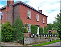
Eau Withington House, Eau Withington
A pleasant red brick Georgian house fronted by surprisingly fine cast-iron railings (Image]). Grade II listed.
Image: © Stephen Richards
Taken: 12 Aug 2013
0.03 miles
2
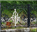
Detail of Eau Withington House, Eau Withington
Anthemia, "Catherine-wheel" patterns and Vitruvian scroll on the railings of this house Image
Image: © Stephen Richards
Taken: 12 Aug 2013
0.03 miles
4
Old Boundary Marker on the A465
Railway Boundary Marker at Eau Withington on the southeast side of the A465 northeast of the railway bridge. On the boundary of Lugwardine and Withington parishes. In raised lettering GREAT WESTERN RAILWAY CoS (outer edge) / BOUNDARY / 1895 (centre).
Milestone Society National ID: HF_LUGWIT01em
Image: © Roadside Relics
Taken: 15 Apr 2023
0.19 miles
6
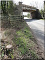
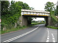
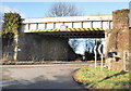
Railway bridge over the A465, Eau Withington
Carries the line from Hereford to Worcester.
Image: © JThomas
Taken: 11 Aug 2021
0.21 miles
7
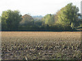
Field of stubble, Nunnington
Tough stalks of an oilseed rape crop still standing in this arable field.
Image: © Pauline E
Taken: 31 Oct 2008
0.21 miles
9
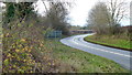
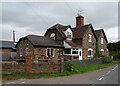
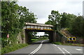
The Bromyard Road, A465
Looking towards Hereford at Eau Withington.
Image: © Jonathan Billinger
Taken: 15 Dec 2014
0.23 miles
10
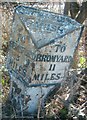
Old Milepost by the A465, Eau Withington
Cast iron post by the A465, in parish of LUGWARDINE (0 District), Builth Farm, just South of railway bridge and junction with Lumber Lane, by the road, on South East side of road. Hereford iron T-post, erected by the Hereford turnpike trust in the 19th century.
Inscription reads:-
: TO / HEREFORD / 3 / MILES : : LUGWARDINE / PARISH :
: TO / BROMYARD / 11 / MILES :
Grade II listed. List Entry Number: 1262996
https://historicengland.org.uk/listing/the-list/list-entry/1262996
Milestone Society National ID: HF_HFBY03.
Image: © Robert Walker
Taken: 26 Nov 2011
0.23 miles