IMAGES TAKEN NEAR TO
Lugg Bridge, HEREFORD, HR1 3ND
Introduction
This page details the photographs taken nearby to HR1 3ND by members of the Geograph project.
The Geograph project started in 2005 with the aim of publishing, organising and preserving representative images for every square kilometre of Great Britain, Ireland and the Isle of Man.

There are currently over 7.5m images from over14,400 individuals and you can help contribute to the project by visiting https://www.geograph.org.uk
Image Map
Images are licensed for reuse under creativecommons.org/licenses/by-sa/2.0
Notes
- Clicking on the map will re-center to the selected point.
- The higher the marker number, the further away the image location is from the centre of the postcode.
Image Listing (14 Images Found)
Images are licensed for reuse under creativecommons.org/licenses/by-sa/2.0
Image
Details
Distance
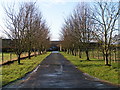
2
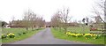
Cotts Farm
A mid-April (Maundy Thursday) view down the avenue to the farm.
Image: © Bob Embleton
Taken: 13 Apr 2006
0.13 miles
3
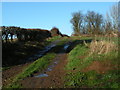
Farm track from the A4103 near Cotts Farm
Image: © Rob Purvis
Taken: 26 Dec 2009
0.15 miles
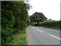
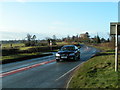
7
A465 towards Hereford
Looking into the sun with a mucky lens!
Image: © Jonathan Billinger
Taken: 12 Oct 2015
0.19 miles
8
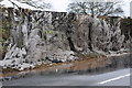
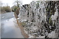
Hedge icicles
Quite a remarkable sight, over recent days as cars have driven through this large puddle on the road the spray has hit the hedge and created a thick layer of ice creating icicles in the hedge.
Image: © Philip Halling
Taken: 29 Mar 2013
0.19 miles
9
Hedge icicles
Quite a remarkable sight, over recent days as cars have driven through this large puddle on the road the spray has hit the hedge and created a thick layer of ice creating icicles in the hedge.
Image: © Philip Halling
Taken: 29 Mar 2013
0.19 miles
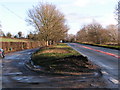
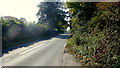
10
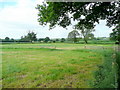
The Lugg floodplain
Viewed from the bridleway to New Court off the A4103.
Image: © Jonathan Billinger
Taken: 12 Jun 2010
0.21 miles