IMAGES TAKEN NEAR TO
Sutton St. Nicholas, HEREFORD, HR1 3HJ
Introduction
This page details the photographs taken nearby to HR1 3HJ by members of the Geograph project.
The Geograph project started in 2005 with the aim of publishing, organising and preserving representative images for every square kilometre of Great Britain, Ireland and the Isle of Man.

There are currently over 7.5m images from over14,400 individuals and you can help contribute to the project by visiting https://www.geograph.org.uk
Image Map
Images are licensed for reuse under creativecommons.org/licenses/by-sa/2.0
Notes
- Clicking on the map will re-center to the selected point.
- The higher the marker number, the further away the image location is from the centre of the postcode.
Image Listing (7 Images Found)
Images are licensed for reuse under creativecommons.org/licenses/by-sa/2.0
Image
Details
Distance
1
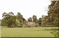
Vennwood, Bodenham
The sudden sight of miniature parkland comes as a delightful surprise amid all the agricultural land on the road from Bodenham to Sutton St. Nicholas. The house seems to date from the 1830s, but very little is recorded about it.
Image: © Philip Pankhurst
Taken: 29 May 2010
0.00 miles

3
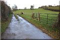
Road to Vennwood
Access road to Vennwood and also the route of a bridleway.
Image: © Philip Halling
Taken: 1 Dec 2012
0.16 miles
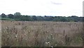
5
Orchard near Upper Holbach
A passing resident of the area told me that deer can sometimes be seen here emerging from Venn Wood above the orchard.
Image: © Bob Embleton
Taken: 15 Apr 2006
0.23 miles

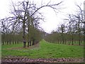
7
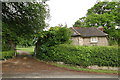
The Lodge, Vennwood
The entrance to the park, also giving access to the serpentine drive that leads to the house.
Image: © Philip Pankhurst
Taken: 29 May 2010
0.24 miles