IMAGES TAKEN NEAR TO
Marden, HEREFORD, HR1 3EN
Introduction
This page details the photographs taken nearby to HR1 3EN by members of the Geograph project.
The Geograph project started in 2005 with the aim of publishing, organising and preserving representative images for every square kilometre of Great Britain, Ireland and the Isle of Man.

There are currently over 7.5m images from over14,400 individuals and you can help contribute to the project by visiting https://www.geograph.org.uk
Image Map
Images are licensed for reuse under creativecommons.org/licenses/by-sa/2.0
Notes
- Clicking on the map will re-center to the selected point.
- The higher the marker number, the further away the image location is from the centre of the postcode.
Image Listing (18 Images Found)
Images are licensed for reuse under creativecommons.org/licenses/by-sa/2.0
Image
Details
Distance

3
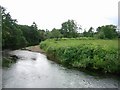
River Lugg
West of Stony Cross, part of a very sharp bend in the river.
Image: © Hugh Venables
Taken: 9 Jul 2006
0.19 miles
4
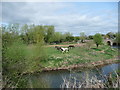
Horses in the meadow at Laystone Bridge, Marden
The Skewbald horse was really energised, encouraging its fellows to rear and trot and at one point they all cantered around the field, then stopped off for a drink in the River Lugg.
Image: © Jeremy Bolwell
Taken: 7 Apr 2011
0.20 miles
6
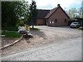
The Big Society in operation in Marden
I thought that "where there's muck there's brass" but I'm glad to see that the operator of a stables in the village can see the bigger picture and is offering, in Springtime, large sacks of horse manure free to any takers. What an offer. Everyone wins.
Image: © Jeremy Bolwell
Taken: 7 Apr 2011
0.22 miles
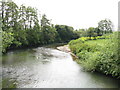
7
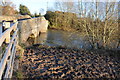
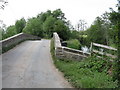
Laystone Bridge
Laystone Bridge crossing a flooded River Lugg into the village of Marden.
Image: © Philip Halling
Taken: 1 Dec 2012
0.23 miles
8
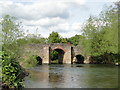
Laystone Bridge, Marden
Over the River Lugg and dating from the 17th century. The heightened centre arch is a century younger, suggesting that in the 18th century the river was navigable here.
Image: © Philip Pankhurst
Taken: 15 May 2010
0.23 miles
10
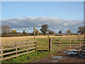
Footpath east from Marden
Towards an area of polytunnels - with the covers removed at the moment.
Image: © Pauline E
Taken: 18 Nov 2008
0.23 miles