IMAGES TAKEN NEAR TO
Lyde Cross, HEREFORD, HR1 3AE
Introduction
This page details the photographs taken nearby to HR1 3AE by members of the Geograph project.
The Geograph project started in 2005 with the aim of publishing, organising and preserving representative images for every square kilometre of Great Britain, Ireland and the Isle of Man.

There are currently over 7.5m images from over14,400 individuals and you can help contribute to the project by visiting https://www.geograph.org.uk
Image Map
Images are licensed for reuse under creativecommons.org/licenses/by-sa/2.0
Notes
- Clicking on the map will re-center to the selected point.
- The higher the marker number, the further away the image location is from the centre of the postcode.
Image Listing (12 Images Found)
Images are licensed for reuse under creativecommons.org/licenses/by-sa/2.0
Image
Details
Distance
1
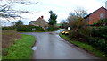
Lyde Cross
A small hamlet based around this staggered road junction.
Looks like a chapel window in the house to the right.
Image: © Jonathan Billinger
Taken: 5 Jan 2016
0.03 miles
2
Footpath and muddy track
Heading west from Lyde Cross.
Image: © Jonathan Billinger
Taken: 5 Jan 2016
0.05 miles
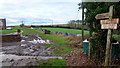
4
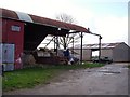
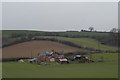
Farmyard, Lyde Cross
Old farmyard, with decaying Dutch barn.
Image: © Richard Webb
Taken: 1 Apr 2006
0.11 miles
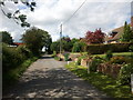
6
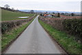
Road to Lower Lyde
The country road to Lower Lyde passing New Cottages which can be seen on the right.
Image: © Philip Halling
Taken: 29 Mar 2013
0.14 miles
7
New Cottages near Lyde Cross
Viewed from the driveway to lower Lyde Court.
Image: © John Winder
Taken: 20 Jan 2015
0.16 miles
10
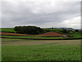
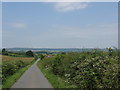
Fields and wood near Lyde Cross
Rolling agricultural land with a small square patch of woodland N of Hereford.
Image: © Trevor Littlewood
Taken: 2 Oct 2010
0.19 miles