IMAGES TAKEN NEAR TO
St. Owen Street, HEREFORD, HR1 2QE
Introduction
This page details the photographs taken nearby to St. Owen Street, HR1 2QE by members of the Geograph project.
The Geograph project started in 2005 with the aim of publishing, organising and preserving representative images for every square kilometre of Great Britain, Ireland and the Isle of Man.

There are currently over 7.5m images from over14,400 individuals and you can help contribute to the project by visiting https://www.geograph.org.uk
Image Map
Images are licensed for reuse under creativecommons.org/licenses/by-sa/2.0
Notes
- Clicking on the map will re-center to the selected point.
- The higher the marker number, the further away the image location is from the centre of the postcode.
Image Listing (453 Images Found)
Images are licensed for reuse under creativecommons.org/licenses/by-sa/2.0
Image
Details
Distance
1
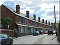
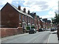
106-120 St Owen's Street, Hereford
Fairly standard Edwardian houses elevated just a little in the hands of Groome & Bettington. Dated 1904.
Image: © Stephen Richards
Taken: 12 Aug 2013
0.01 miles
3
OS Benchmark, St Giles' Chapel
Such a well-preserved mark I almost wonder if it has been recreated. 54.70m above OSDN.
Image: © Keith Edkins
Taken: 14 Jul 2013
0.02 miles
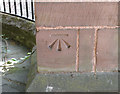
4
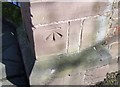
Ordnance Survey Cut Mark
This OS cut mark can be found on a wall post in front of St Giles Chapel. It marks a point 54.709m above mean sea level.
Image: © Adrian Dust
Taken: 10 Mar 2019
0.02 miles
6
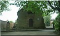
St. Giles's Chapel (Hereford)
And no-one ever turns to look at this brilliant chapel in Hereford. Such a shame.
Anyways, this chapel has had some huge differences during the modern era. It used to be placed nearby the St. Giles's almshouses, but around 1927, it had to be placed somewhere else due to road widening. It was then rebuilt to the left side of Williams Almshouses, and here it is today!
Image: © Fabian Musto
Taken: 23 May 2018
0.02 miles
7
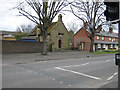
St. Giles's Chapel, St. Owen's Street
The chapel is 17th century and once stood on the corner of St. Owen's Street. It was rebuilt next to the almshouses in 1927.
Image: © Pauline E
Taken: 25 Mar 2008
0.03 miles
8
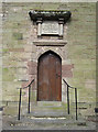
Doorway of St. Giles's Chapel, Hereford
The 17th century chapel once stood on the corner of St. Owen's Street. It was rebuilt next to the almshouses in 1927.
Image: © Pauline E
Taken: 25 Mar 2008
0.03 miles
9
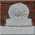
Fire insurance plaque
An old fire insurance plaque on the front of the Williams Almshouses.
Image: © Philip Halling
Taken: 16 Oct 2023
0.03 miles