IMAGES TAKEN NEAR TO
Bath Street, HEREFORD, HR1 2HG
Introduction
This page details the photographs taken nearby to Bath Street, HR1 2HG by members of the Geograph project.
The Geograph project started in 2005 with the aim of publishing, organising and preserving representative images for every square kilometre of Great Britain, Ireland and the Isle of Man.

There are currently over 7.5m images from over14,400 individuals and you can help contribute to the project by visiting https://www.geograph.org.uk
Image Map
Images are licensed for reuse under creativecommons.org/licenses/by-sa/2.0
Notes
- Clicking on the map will re-center to the selected point.
- The higher the marker number, the further away the image location is from the centre of the postcode.
Image Listing (1128 Images Found)
Images are licensed for reuse under creativecommons.org/licenses/by-sa/2.0
Image
Details
Distance
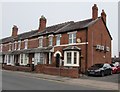
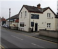
1
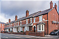
Wyecliffe Terrace
Turn of the 19th/20th Centuries terrace on Bath Street, first shown on the 1904 25 inch map.
Image: © Ian Capper
Taken: 22 Feb 2022
0.01 miles
2
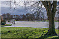
Bishop's Meadow in flood
Open space south of the River Wye, seen here under water due to flooding from the river following storms Eunice and Franklin.
Image: © Ian Capper
Taken: 22 Feb 2022
0.01 miles
3
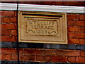
Wyecliff Terrace 1888 name tablet, Hereford
In the middle of this row http://www.geograph.org.uk/photo/5175112 between first floor windows.
Image: © Jaggery
Taken: 31 Oct 2016
0.01 miles
4
Wyecliff Terrace, Bath Street, Hereford
A tablet http://www.geograph.org.uk/photo/5175125 between first floor windows shows WYECLIFF TERRACE 1888.
Image: © Jaggery
Taken: 31 Oct 2016
0.01 miles
5
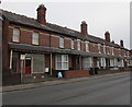
Brighton Villa Dental Care, Hereford
The dental surgery on the right is in Brighton Villa, 7 Bath Street.
Image: © Jaggery
Taken: 31 Oct 2016
0.02 miles
6
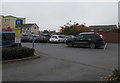
Pay & display car park entrance from Bath Street, Hereford
The notice on the left states that charges apply here 24 hours a day,
7 days a week. All parking must be paid for - blue badge holders are not exempt.
Image: © Jaggery
Taken: 31 Oct 2016
0.02 miles
7
Venn's Close
Cul-de-sac of 17 houses off Bath Street, built in 1937-8, designed by R A Ford.
Image: © Ian Capper
Taken: 22 Feb 2022
0.02 miles
8
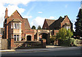
Venn's Close, off Bath Street
John Venn was one of Hereford's foremost philanthropists. Amongst other things, he laid the foundation stone for St Peter's Parish School, founded the Hereford Friendly Society, and in 1841, the Hereford Society for Aiding the Industrious. I can find no other information relating to these buildings linked by an archway, on Bath Street (formerly Brookside) at the moment. (Appears to bisect the grid line on my map)
Image: © Pauline E
Taken: 17 Oct 2008
0.02 miles
9
Kyrle House, Hereford
Osteopathic practice in Kyrle Street.
Image: © Jaggery
Taken: 31 Oct 2016
0.03 miles
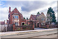
10
Hereford police station
Here is the police station building on Bath Street, built during the 1970s or 1980s.
Image: © Fabian Musto
Taken: 8 Jul 2021
0.03 miles