IMAGES TAKEN NEAR TO
Kyrle Street, HEREFORD, HR1 2EW
Introduction
This page details the photographs taken nearby to Kyrle Street, HR1 2EW by members of the Geograph project.
The Geograph project started in 2005 with the aim of publishing, organising and preserving representative images for every square kilometre of Great Britain, Ireland and the Isle of Man.

There are currently over 7.5m images from over14,400 individuals and you can help contribute to the project by visiting https://www.geograph.org.uk
Image Map
Images are licensed for reuse under creativecommons.org/licenses/by-sa/2.0
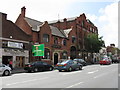
Notes
- Clicking on the map will re-center to the selected point.
- The higher the marker number, the further away the image location is from the centre of the postcode.
Image Listing (1119 Images Found)
Images are licensed for reuse under creativecommons.org/licenses/by-sa/2.0
Image
Details
Distance
1
Pubs & Cafes, Commercial Road, Hereford
Image: © Peter Whatley
Taken: 23 Jun 2009
0.01 miles
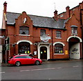
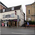
2
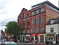
58 Commercial Road, Hereford
Built as Greenlands Repository by W.W. Robinson, 1903, and Hereford's first steel-framed building. The plain bit on the right is C20th.
Now flats, Jacobs Court.
Image: © Stephen Richards
Taken: 12 Aug 2013
0.01 miles
3
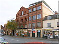
Jacobs Court, Commercial Road, Hereford
Jacobs Court building.
Image: © Alan Spencer
Taken: 1 Nov 2009
0.01 miles
4

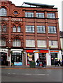
Yates, Hereford
Bar/restaurant at 58 Commercial Road.
Image: © Jaggery
Taken: 11 Jan 2016
0.02 miles
5
Munchies, Hereford
Commercial Road takeaway located between Yates bar/restaurant http://www.geograph.org.uk/photo/4796371 and Wok & Rice noodle bar.
Image: © Jaggery
Taken: 11 Jan 2016
0.02 miles
6
Former BBQs & Brews, Hereford
Premises at 59 Commercial Road, viewed in January 2016. The Hereford Times reported that BBQs & Brews had opened here in September 2014, replacing The Hop Pole. The restaurant/bar, which based its menu on American Deep South pit barbecues, closed down on October 4th 2015.
Image: © Jaggery
Taken: 11 Jan 2016
0.02 miles
7
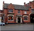
Hogarths pub in Hereford
Hogarths at 59 Commercial Road is an Amber Taverns Victorian-style gin palace, with 125 types of gin on sale.
Image: © Jaggery
Taken: 30 Jan 2017
0.02 miles
8
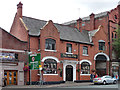
Hop Pole, Commercial Road, Hereford
"Pleasant brick pub with shaped gables" by W.E. Britten, 1903.
Image: © Stephen Richards
Taken: 12 Aug 2013
0.02 miles
9
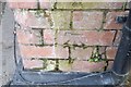
Ordnance Survey Cut Mark
This OS cut mark can be found on the Hop Pole Hotel. It marks a point 54.334m above mean sea level.
Image: © Adrian Dust
Taken: 10 Mar 2019
0.02 miles
10
The Glass Tandoori, Hereford
Commercial Road restaurant & takeaway between a fish & chips shop and Hereford Baptist Church. http://www.geograph.org.uk/photo/4796250
Image: © Jaggery
Taken: 11 Jan 2016
0.02 miles