IMAGES TAKEN NEAR TO
Catherine Street, HEREFORD, HR1 2DU
Introduction
This page details the photographs taken nearby to Catherine Street, HR1 2DU by members of the Geograph project.
The Geograph project started in 2005 with the aim of publishing, organising and preserving representative images for every square kilometre of Great Britain, Ireland and the Isle of Man.

There are currently over 7.5m images from over14,400 individuals and you can help contribute to the project by visiting https://www.geograph.org.uk
Image Map
Images are licensed for reuse under creativecommons.org/licenses/by-sa/2.0
Notes
- Clicking on the map will re-center to the selected point.
- The higher the marker number, the further away the image location is from the centre of the postcode.
Image Listing (1159 Images Found)
Images are licensed for reuse under creativecommons.org/licenses/by-sa/2.0
Image
Details
Distance
1
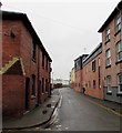
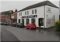
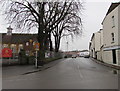
West along Catherine Street, Hereford
From the corner of Monkmoor Street.
Image: © Jaggery
Taken: 30 Jan 2017
0.01 miles
2
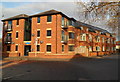
Charles Court flats, Hereford
Located on the corner of Coningsby Street and Canal Road.
Image: © Jaggery
Taken: 13 Jan 2012
0.02 miles
3
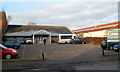
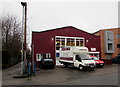
Canal Road Day Centre, Hereford
Herefordshire Council premises located on the west side of Canal Road in central Hereford, about 150 metres north of Commercial Road.
The day centre has services and facilities designed to help physically or mentally impaired adults remain in the community. It also provides carers the opportunity to have a break from their caring role.
Overnight frost remains on the lower part of the roof.
Image: © Jaggery
Taken: 13 Jan 2012
0.02 miles
4
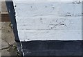
Ordnance Survey Cut Mark
This OS cut mark can be found on the Bicycle Shop, Coningsby Street. It marks a point 55.428m above mean sea level.
Image: © Adrian Dust
Taken: 10 Mar 2019
0.02 miles
5
Climb On Bikes, Hereford
Bicycle shop at 24-25 Coningsby Street.
Image: © Jaggery
Taken: 30 Jan 2017
0.03 miles
6
Philip Morris & Son van in the Goods In area, Hereford
Viewed across Coningsby Street. Text on the side of the van includes
Philip Morris & Son The home & country department store 18 & 23 Widemarsh Street Hereford.
Image: © Jaggery
Taken: 30 Jan 2017
0.03 miles
7
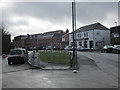
Coningsby Street (Hereford)
Here is Coningsby Street, viewed from a path nearby the St. Thomas Cantilupe Church of England Primary School.
Image: © Fabian Musto
Taken: 10 Mar 2018
0.03 miles
8
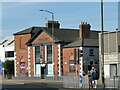
Former Bluecoat School, Blue School Street, Hereford
'Bluecoats' schools are found in many parts of England. This building, dating from 1710, is no longer a school, but 'Play' - a bar and nightclub. See Image for a closer view. The school as an institution is now located on Ledbury Road, 2km away Image
Image: © Stephen Craven
Taken: 18 Oct 2022
0.03 miles
9
Coningsby Street, Hereford
Viewed across Widemarsh Street. St Thomas Cantilupe Church of England Primary School http://www.geograph.org.uk/photo/3502946 is on the left.
Image: © Jaggery
Taken: 30 Jan 2017
0.03 miles
10
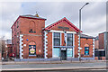
51 - 55 Blue School Street
Former Bluecoat Schools building, built in 1827, now housing the Play nightclub. The inscription in the gable reads "Blue Coat Schools Established AD 1710", referring to the original foundation of the school. The architect was Charles Heather, who was responsible for a number of buildings around Hereford.
Image: © Ian Capper
Taken: 22 Feb 2022
0.04 miles