IMAGES TAKEN NEAR TO
Coningsby Street, HEREFORD, HR1 2DQ
Introduction
This page details the photographs taken nearby to Coningsby Street, HR1 2DQ by members of the Geograph project.
The Geograph project started in 2005 with the aim of publishing, organising and preserving representative images for every square kilometre of Great Britain, Ireland and the Isle of Man.

There are currently over 7.5m images from over14,400 individuals and you can help contribute to the project by visiting https://www.geograph.org.uk
Image Map
Images are licensed for reuse under creativecommons.org/licenses/by-sa/2.0
Notes
- Clicking on the map will re-center to the selected point.
- The higher the marker number, the further away the image location is from the centre of the postcode.
Image Listing (1096 Images Found)
Images are licensed for reuse under creativecommons.org/licenses/by-sa/2.0
Image
Details
Distance
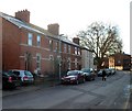
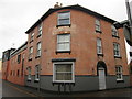
1
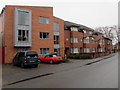
Modern housing in Coningsby Street Hereford
Looking east along Coningsby Street towards the Canal Road junction.
Image: © Jaggery
Taken: 30 Jan 2017
0.00 miles
2
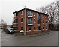
Charles Court, Hereford
On the corner of Coningsby Street and Canal Road. Confusingly, the street name sign near the car shows Coningsby Court whereas the blue nameplate above the door on the right shows Charles Court.
Image: © Jaggery
Taken: 30 Jan 2017
0.01 miles
3
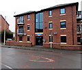
Charles Court, Hereford
On the corner of Coningsby Street and Canal Road. The name sign shows CHARLES COURT FLATS 1-6.
Image: © Jaggery
Taken: 30 Jan 2017
0.01 miles
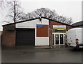
4
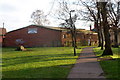
Bodyworx Gym, Hereford
Set back from the east side of Canal Road. The grounds were formerly a cemetery. Gravestones are arranged along the sides of the building.
Image: © Jaggery
Taken: 13 Jan 2012
0.01 miles
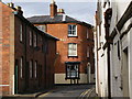
5
Canal Road houses, Hereford
The houses are opposite Canal Road Day Centre. http://www.geograph.org.uk/photo/2765480
Image: © Jaggery
Taken: 13 Jan 2012
0.01 miles
6
Steve Lindsay Hereford
Windows and conservatories business at 41 Monkmoor Street.
Image: © Jaggery
Taken: 30 Jan 2017
0.02 miles
7
The Nell Gwynne, Public House
The Nell Gwynne, pub corner of Monksmore Street and Catherine Street, Hereford.
Nell Gwynne was reputedly born in Hereford, in a house in Pipewell Lane, Later called Gwynne Street.
Image: © Alan Spencer
Taken: 1 Nov 2009
0.02 miles
8

Ordnance Survey Cut Mark
This OS cut mark can be found on the former British Oak Public House. It marks a point 55.233m above mean sea level.
Image: © Adrian Dust
Taken: 10 Mar 2019
0.02 miles
9
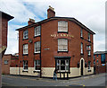
Nell Gwynne, Monkmoor Street, Hereford
Victorian pub with a rounded corner into Catherine Street. Dated 1862.
Image: © Stephen Richards
Taken: 12 Aug 2013
0.02 miles
10
Nell Gwynne (Hereford)
Now converted into housing, this used to be a pub dedicated to Nell Gwynne.
Quite surprised that this viewpoint looks similar to Jaggery's photograph of the same building. https://www.geograph.org.uk/photo/5274853
Image: © Fabian Musto
Taken: 10 Mar 2018
0.02 miles