IMAGES TAKEN NEAR TO
Puers Field, BEACONSFIELD, HP9 2TF
Introduction
This page details the photographs taken nearby to Puers Field, HP9 2TF by members of the Geograph project.
The Geograph project started in 2005 with the aim of publishing, organising and preserving representative images for every square kilometre of Great Britain, Ireland and the Isle of Man.

There are currently over 7.5m images from over14,400 individuals and you can help contribute to the project by visiting https://www.geograph.org.uk
Image Map
Images are licensed for reuse under creativecommons.org/licenses/by-sa/2.0
Notes
- Clicking on the map will re-center to the selected point.
- The higher the marker number, the further away the image location is from the centre of the postcode.
Image Listing (17 Images Found)
Images are licensed for reuse under creativecommons.org/licenses/by-sa/2.0
Image
Details
Distance
3
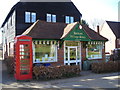
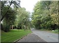
Jordans Village Store
The village store has been in business since 1922. It is owned, operated and controlled by the village and run by a combination of part-time staff and volunteers from the local community.
Image: © Mark Percy
Taken: 2 Apr 2013
0.16 miles
5
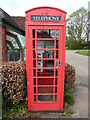
Red K6 Telephone Box in Jordans village
This telephone box is located by Jordans Village Store in Green West Road, HP9 2SY. Its payphone has now been taken out and an Audio History of Jordans Village installed instead. Details of Jordans village can be found at https://www.jordansvillage.co.uk/index.html. Green North Road can just be seen to the right of the photo.
Image: © David Hillas
Taken: 18 Apr 2022
0.18 miles
6
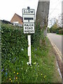
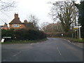
Old Road Sign in Seer Green Lane, Jordans
This photo shows the old road sign located in Seer Green Lane HP9 2ST and which is missing its red circle with inverted triangle above it. During the mid-1960s, this particular sign was replaced by the inverted triangle "Give Way" sign. This road leads to Jordans Lane in the distance.
Image: © David Hillas
Taken: 18 Apr 2022
0.19 miles

9
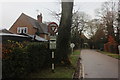
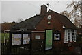
Approaching Jordans Lane
A vintage road sign.
Image: © Robert Eva
Taken: 22 Nov 2016
0.20 miles