IMAGES TAKEN NEAR TO
Crosby Close, BEACONSFIELD, HP9 2JU
Introduction
This page details the photographs taken nearby to Crosby Close, HP9 2JU by members of the Geograph project.
The Geograph project started in 2005 with the aim of publishing, organising and preserving representative images for every square kilometre of Great Britain, Ireland and the Isle of Man.

There are currently over 7.5m images from over14,400 individuals and you can help contribute to the project by visiting https://www.geograph.org.uk
Image Map
Images are licensed for reuse under creativecommons.org/licenses/by-sa/2.0
Notes
- Clicking on the map will re-center to the selected point.
- The higher the marker number, the further away the image location is from the centre of the postcode.
Image Listing (257 Images Found)
Images are licensed for reuse under creativecommons.org/licenses/by-sa/2.0
Image
Details
Distance
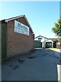
3
Approaching the junction of Malthouse Square and Crosby Close
Image: © Basher Eyre
Taken: 25 Sep 2010
0.05 miles
4
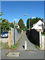
Path from Malthouse Square to London End
Image: © Basher Eyre
Taken: 25 Sep 2010
0.05 miles
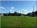
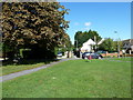
6
A September morning in Malthouse Square
Image: © Basher Eyre
Taken: 25 Sep 2010
0.05 miles
7
Looking from Malthouse Square into Crosby Close
Image: © Basher Eyre
Taken: 25 Sep 2010
0.05 miles
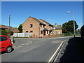
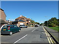
8

What on Earth Happened to The Greyhound?
Image: © Ivan Hall
Taken: 18 Aug 2010
0.06 miles
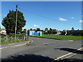
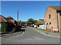
9
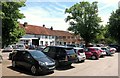
Not so much a town.....
....More a car park with buildings.
Beaconsfield has a vehicle problem.
In the background is an Italian restaurant called Enoteca.
I think that answers Ivan Hall's question. Image
Image: © Des Blenkinsopp
Taken: 18 Jun 2015
0.06 miles