IMAGES TAKEN NEAR TO
Shepherds Lane, BEACONSFIELD, HP9 2DU
Introduction
This page details the photographs taken nearby to Shepherds Lane, HP9 2DU by members of the Geograph project.
The Geograph project started in 2005 with the aim of publishing, organising and preserving representative images for every square kilometre of Great Britain, Ireland and the Isle of Man.

There are currently over 7.5m images from over14,400 individuals and you can help contribute to the project by visiting https://www.geograph.org.uk
Image Map
Images are licensed for reuse under creativecommons.org/licenses/by-sa/2.0
Notes
- Clicking on the map will re-center to the selected point.
- The higher the marker number, the further away the image location is from the centre of the postcode.
Image Listing (234 Images Found)
Images are licensed for reuse under creativecommons.org/licenses/by-sa/2.0
Image
Details
Distance
1
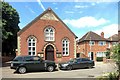
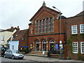
Wesleyan Reform Chapel 1900
Along Shepherds Lane in Beaconsfield old town.
The term Reform Chapel refers to a faction within the Methodist movement.
Wikipedia says this
"The Wesleyan Reform Union is an Independent Methodist Connexion based in the United Kingdom. It was founded in 1859 by the members of the Wesleyan Reform movement who did not join the United Methodist Free Churches."
Details on https://en.wikipedia.org/wiki/Wesleyan_Reform_Union
Image: © Des Blenkinsopp
Taken: 18 Jun 2015
0.05 miles
2
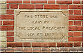
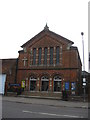
Local Preachers' Stone
One of four foundation stones on the front of the Wesleyan chapel in Shepherds Lane. Image
In contrast with the other stones which proudly name various worthys of the day, this one seems strangely anonymous.
Modesty is a virtue, so they say.
Image: © Des Blenkinsopp
Taken: 18 Jun 2015
0.05 miles
3
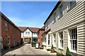
Brasserie Blanc
One of a number of short lanes leading off the main streets.
Now home to smart businesses like this French restaurant, these were probably old work yards in former times.
Image: © Des Blenkinsopp
Taken: 18 Jun 2015
0.08 miles
4
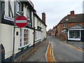
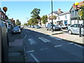
Shepherds Lane, Beaconsfield
Leading north-east from the town centre.
Image: © Jonathan Billinger
Taken: 30 Sep 2008
0.09 miles
5
Beaconsfield United Reformed Church
Red-brick building situated on the east side of Aylesbury End in the town centre.
Image: © Jonathan Billinger
Taken: 30 Sep 2008
0.09 miles
6
United Reformed Church, Beaconsfield
The present church was built in 1874-5.
Image: © Richard Rogerson
Taken: 29 May 2010
0.09 miles
8
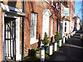
Georgian Beaconsfield
Historic brick buildings with attractive doorways. These are on the northern side of the old main street, the former main road between London and Oxford.
http://www.beaconsfield.co.uk/
Image: © Colin Smith
Taken: 18 Jan 2009
0.09 miles
9
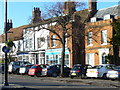
Old Town Centre, Beaconsfield
A pleasing mix of old brick buildings on the A40, the old main road from London to Oxford. As well as being bypassed courtesy of the M40, the old town shopping centre has also been bypassed by a modern counterpart 1 mile north, by the railway station.
http://www.beaconsfield.co.uk/
Image: © Colin Smith
Taken: 18 Jan 2009
0.09 miles
10
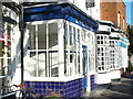
The Old Town Friar
Chips at the old block here in central Beaconsfield Old Town. Attractive bow windows face on to the old London - Oxford main road.
http://www.beaconsfield.co.uk/
Image: © Colin Smith
Taken: 18 Jan 2009
0.09 miles