IMAGES TAKEN NEAR TO
Howe Drive, BEACONSFIELD, HP9 2BD
Introduction
This page details the photographs taken nearby to Howe Drive, HP9 2BD by members of the Geograph project.
The Geograph project started in 2005 with the aim of publishing, organising and preserving representative images for every square kilometre of Great Britain, Ireland and the Isle of Man.

There are currently over 7.5m images from over14,400 individuals and you can help contribute to the project by visiting https://www.geograph.org.uk
Image Map
Images are licensed for reuse under creativecommons.org/licenses/by-sa/2.0
Notes
- Clicking on the map will re-center to the selected point.
- The higher the marker number, the further away the image location is from the centre of the postcode.
Image Listing (8 Images Found)
Images are licensed for reuse under creativecommons.org/licenses/by-sa/2.0
Image
Details
Distance
1
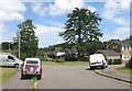
Copperfields, Beaconsfield
A couple of short suburban streets are in the SW corner of this square which is otherwise mostly fields and woods.
Image: © Des Blenkinsopp
Taken: 18 Jun 2015
0.12 miles

3
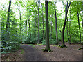
Path in Netherlands Wood
This is a public footpath, although signs put up by the Penn House estate say 'Walkers are welcome', so presumably you can walk anywhere.
Image: © Robin Webster
Taken: 28 Jul 2017
0.17 miles
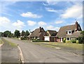
4
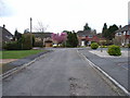
Upper Drive, Knotty Green
Northern suburb of Beaconsfield but within Penn parish.
Image: © Andrew Smith
Taken: 9 Apr 2006
0.20 miles
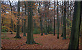
6
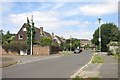
Browns Wood
The path going straight on leads to Netherlands Wood and, further on, Great Beards Wood.
Image: © Robert Eva
Taken: 22 Nov 2016
0.23 miles
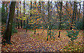
8
Autumn in Brown's Wood
Late November but there is still some fine Autumn colour. The marks on the trees are very helpful since, at this time of year, the path is buried.
Image: © Robert Eva
Taken: 22 Nov 2016
0.24 miles