IMAGES TAKEN NEAR TO
Berkley Road, BEACONSFIELD, HP9 2AY
Introduction
This page details the photographs taken nearby to Berkley Road, HP9 2AY by members of the Geograph project.
The Geograph project started in 2005 with the aim of publishing, organising and preserving representative images for every square kilometre of Great Britain, Ireland and the Isle of Man.

There are currently over 7.5m images from over14,400 individuals and you can help contribute to the project by visiting https://www.geograph.org.uk
Image Map (Loading...)


Getting Data...Please wait
Leaflet Map data © OpenStreetMap
Images are licensed for reuse under creativecommons.org/licenses/by-sa/2.0
Notes
- Clicking on the map will re-center to the selected point.
- The higher the marker number, the further away the image location is from the centre of the postcode.
Image Listing (6 Images Found)
Images are licensed for reuse under creativecommons.org/licenses/by-sa/2.0
Image
Details
Distance
3
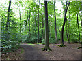
Path in Netherlands Wood
This is a public footpath, although signs put up by the Penn House estate say 'Walkers are welcome', so presumably you can walk anywhere.
Image: © Robin Webster
Taken: 28 Jul 2017
0.18 miles

5
Browns Wood
The path going straight on leads to Netherlands Wood and, further on, Great Beards Wood.
Image: © Robert Eva
Taken: 22 Nov 2016
0.19 miles
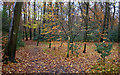
6
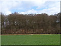
Sandels Wood
Part of the Penn House Estate. Permissive access is allowed in this and Netherlands Wood.
Image: © Andrew Smith
Taken: 9 Apr 2006
0.24 miles