IMAGES TAKEN NEAR TO
Wattleton Road, BEACONSFIELD, HP9 1RW
Introduction
This page details the photographs taken nearby to Wattleton Road, HP9 1RW by members of the Geograph project.
The Geograph project started in 2005 with the aim of publishing, organising and preserving representative images for every square kilometre of Great Britain, Ireland and the Isle of Man.

There are currently over 7.5m images from over14,400 individuals and you can help contribute to the project by visiting https://www.geograph.org.uk
Image Map
Images are licensed for reuse under creativecommons.org/licenses/by-sa/2.0
Notes
- Clicking on the map will re-center to the selected point.
- The higher the marker number, the further away the image location is from the centre of the postcode.
Image Listing (49 Images Found)
Images are licensed for reuse under creativecommons.org/licenses/by-sa/2.0
Image
Details
Distance
1
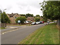
Wattleton Road with Butlers Court School entrance
There are signs prohibiting parking on the road outside the school entrance, and also on the grass verge on the right which is outside the playing field of The Beaconsfield School.
Image: © David Hawgood
Taken: 7 Aug 2008
0.05 miles
2
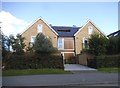
House on Station Road, Beaconsfield
Yes, that's a hole in the roof, and the house next door is identical to it. I think it's a sort of balcony.
Image: © David Howard
Taken: 10 Aug 2017
0.10 miles
3
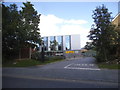
The National Film and Television School, Beaconsfield
Image: © David Howard
Taken: 10 Aug 2017
0.11 miles
5
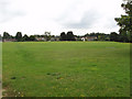
Playing field of The Beaconsfield School
Photo taken from Wattleton Road during the summer holidays of this school http://www.beaconsfield.bucks.sch.uk/.
Image: © David Hawgood
Taken: 7 Aug 2008
0.12 miles
6
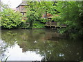
Pond on Candlemas Lane
Pond on Candlemas Lane by Station Road
Image: © Shaun Ferguson
Taken: 13 Jun 2008
0.14 miles
7
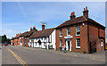
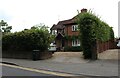
Aylesbury End, Beaconsfield
The road north from the old part of town.
The nearest building is a dentist's.
Image: © Des Blenkinsopp
Taken: 18 Jun 2015
0.15 miles
8
Candlemas Lane at the junction of Station Road
Image: © David Howard
Taken: 24 Jun 2021
0.15 miles
9
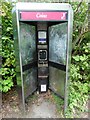
Former KX300 Telephone Kiosk in Candlemas Lane, Beaconsfield
Situated in Candlemas Lane HP9 1AE near Candlemas Mead, this telephone kiosk has already had its payphone taken out and there is a white and blue BT notice mentioning that the kiosk will shortly be removed due to lack of usage. Graffiti can be seen on the glass panels each side of the kiosk. Update: the telephone kiosk has since been removed from this location, which is no surprise.
Image: © David Hillas
Taken: 20 Apr 2017
0.17 miles
10
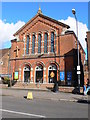
United Reformed Church, Beaconsfield
Built in 1800 and 1874 this church stands on the east side of Aylesbury End. http://www.imagesofengland.org.uk/details/default.aspx?id=475366
Image: © Eirian Evans
Taken: 6 Feb 2008
0.17 miles