IMAGES TAKEN NEAR TO
Beacon Close, BEACONSFIELD, HP9 1RJ
Introduction
This page details the photographs taken nearby to Beacon Close, HP9 1RJ by members of the Geograph project.
The Geograph project started in 2005 with the aim of publishing, organising and preserving representative images for every square kilometre of Great Britain, Ireland and the Isle of Man.

There are currently over 7.5m images from over14,400 individuals and you can help contribute to the project by visiting https://www.geograph.org.uk
Image Map
Images are licensed for reuse under creativecommons.org/licenses/by-sa/2.0
Notes
- Clicking on the map will re-center to the selected point.
- The higher the marker number, the further away the image location is from the centre of the postcode.
Image Listing (19 Images Found)
Images are licensed for reuse under creativecommons.org/licenses/by-sa/2.0
Image
Details
Distance
1
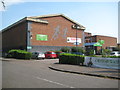
Holtspur: The Beacon Sports Centre and Theatre
Please see http://www.better.org.uk/leisure/the-beacon-sports-centre-and-theatre for the Centre's website. According to the website the theatre "has 209 seats, is fully equipped, and is available to hire by both amateur and professional theatre groups. It is also ideal for organisations wishing to hold conferences and seminars."
Looking at old Ordnance Survey maps the centre was built on the site of the original Holtspur County Primary School, of which Sir Terry Pratchett was once a pupil. Please see this news article on the Bucks Free Press website which also has an oblique aerial photograph of the school, probably taken shortly after its opening in 1951 http://www.bucksfreepress.co.uk/news/9007012.Terry_Pratchett_writes_in_to_his_first_school_for_its_60th_birthday/ .
Image: © Nigel Cox
Taken: 26 Jul 2014
0.02 miles
2
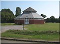
Holtspur: The youth centre
The youth centre is in the north-west corner of the playing field on Holtspur Way. The photographer has unintentionally managed to set up the image so that only three facades of the octagonal structure are visible!
Image: © Nigel Cox
Taken: 26 Jul 2014
0.06 miles
3
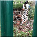
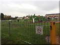
Holtspur Hilton minibeast hotel
Taken from outside the fence looking into the school field.
Image: © Class 1
Taken: 5 Nov 2015
0.06 miles
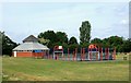
5
The Park
Recently installed play equipment in the park behind the Youth Centre, with flats in the background.
Image: © Class 1
Taken: 5 Nov 2015
0.08 miles
6
Basketball Court and Youth Centre
This is on a small recreation ground along Holtspur Way.
Image: © Des Blenkinsopp
Taken: 18 Jun 2015
0.08 miles
7
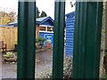
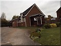
Holtspur Pre-School
Photo of front of building, taken through the gate.
Image: © Class 1
Taken: 5 Nov 2015
0.10 miles
8
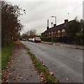
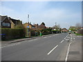
Cherry Tree Road
A typical view of housing on Cherry Tree Road.
Image: © Class 1
Taken: 5 Nov 2015
0.13 miles
10
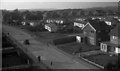
Holtspur, Mayflower Way, 1962
Photograph looking west along Mayflower Way, taken from the top of the tower of St Thomas's Church. The prefabricated houses (single storey) are no longer there.
Image: © Euchiasmus
Taken: Unknown
0.16 miles