IMAGES TAKEN NEAR TO
Hartwell Drive, BEACONSFIELD, HP9 1JA
Introduction
This page details the photographs taken nearby to Hartwell Drive, HP9 1JA by members of the Geograph project.
The Geograph project started in 2005 with the aim of publishing, organising and preserving representative images for every square kilometre of Great Britain, Ireland and the Isle of Man.

There are currently over 7.5m images from over14,400 individuals and you can help contribute to the project by visiting https://www.geograph.org.uk
Image Map
Images are licensed for reuse under creativecommons.org/licenses/by-sa/2.0
Notes
- Clicking on the map will re-center to the selected point.
- The higher the marker number, the further away the image location is from the centre of the postcode.
Image Listing (173 Images Found)
Images are licensed for reuse under creativecommons.org/licenses/by-sa/2.0
Image
Details
Distance

2
Furzefield Road at the junction of Gregories Road
Image: © David Howard
Taken: 17 Feb 2022
0.10 miles
3
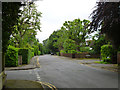
Furzefield Road, Beaconsfield
An area of quite large well-spaced houses.
Image: © Robin Webster
Taken: 18 Jun 2016
0.10 miles
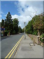
9
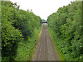
Railway, Beaconsfield
Looking towards the station beyond the bridge. The old Great Western and Great Central joint line, with passenger services now operated by Chiltern Railways.
Image: © Robin Webster
Taken: 18 Jun 2016
0.11 miles