IMAGES TAKEN NEAR TO
Penington Road, BEACONSFIELD, HP9 1ET
Introduction
This page details the photographs taken nearby to Penington Road, HP9 1ET by members of the Geograph project.
The Geograph project started in 2005 with the aim of publishing, organising and preserving representative images for every square kilometre of Great Britain, Ireland and the Isle of Man.

There are currently over 7.5m images from over14,400 individuals and you can help contribute to the project by visiting https://www.geograph.org.uk
Image Map
Images are licensed for reuse under creativecommons.org/licenses/by-sa/2.0
Notes
- Clicking on the map will re-center to the selected point.
- The higher the marker number, the further away the image location is from the centre of the postcode.
Image Listing (24 Images Found)
Images are licensed for reuse under creativecommons.org/licenses/by-sa/2.0
Image
Details
Distance
1
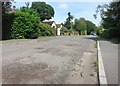
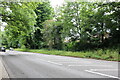
Money can't buy you.......roads?
The rates coming in from Beaconsfield's large stock of comfortably-off housing must be worth quite a bit.
This doesn't look like value for money from the road department.
Pot holes along Penington Road.
Image: © Des Blenkinsopp
Taken: 18 Jun 2015
0.03 miles
2
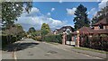
Burgess Wood Road South
Looking north up smart residential road.
Image: © James Emmans
Taken: 4 May 2021
0.09 miles
3
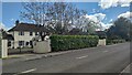
Burgess Wood Road South
Large detached houses of Beaconsfield.
https://en.wikipedia.org/wiki/Beaconsfield
Image: © James Emmans
Taken: 4 May 2021
0.09 miles
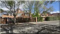
4
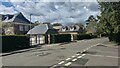
Burkes Road
The southern end of Burkes Road. These detached houses are situated on larger plots of land.
Image: © James Emmans
Taken: 4 May 2021
0.09 miles
6
Burkes Road at the junction of the A40
Image: © David Howard
Taken: 24 Jun 2021
0.12 miles
7
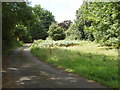
South Drive, Beaconsfield
This short road lies between the A40 beyond the hedge on the right, and the M40 at the bottom of the gardens of five houses which are on the left. So perhaps the rather wild appearance is deliberate.
Image: © David Hawgood
Taken: 7 Aug 2008
0.13 miles
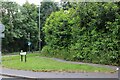
9
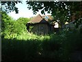
Disused utility building
Now demolished.
Image: © Jeff Tomlinson
Taken: 23 May 2009
0.15 miles
10
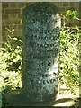
Tithing Stone
Boundary stone between the Wooburn and Beaconsfield parishes.
The inscription is :
3rd May 1827
Boundary Stone
of the Manor and Parish
of Beaconsfield
The custom of tithing
Corn in this Parish is
and has been immemorially
by the TENTH COCK
and the ELEVENTH SHOCK
It was erected to commemorate the winning of a legal dispute by a local farmer.
The farmer had challenged the rights of the Vicar of Beaconsfield with respect to the levying of tithes.
Image: © Jeff Tomlinson
Taken: 23 May 2009
0.15 miles