IMAGES TAKEN NEAR TO
Nightingales Lane, CHALFONT ST. GILES, HP8 4SG
Introduction
This page details the photographs taken nearby to Nightingales Lane, HP8 4SG by members of the Geograph project.
The Geograph project started in 2005 with the aim of publishing, organising and preserving representative images for every square kilometre of Great Britain, Ireland and the Isle of Man.

There are currently over 7.5m images from over14,400 individuals and you can help contribute to the project by visiting https://www.geograph.org.uk
Image Map
Images are licensed for reuse under creativecommons.org/licenses/by-sa/2.0
Notes
- Clicking on the map will re-center to the selected point.
- The higher the marker number, the further away the image location is from the centre of the postcode.
Image Listing (5 Images Found)
Images are licensed for reuse under creativecommons.org/licenses/by-sa/2.0
Image
Details
Distance
1
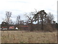
Fields and open air museum, Chalfont St Peter
View east of fields with buildings of open air museum beyond in Newland Park
Image: © David Hawgood
Taken: 17 Feb 2006
0.12 miles
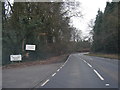
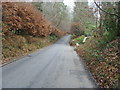
3
Nightingales Lane at the junction of Deadhern Lane
Image: © David Howard
Taken: 8 Oct 2015
0.14 miles
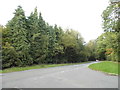
4
Deadhearn Lane, Chalfont St Giles
There are houses on the left but hidden behind the trees
Image: © David Howard
Taken: 8 Oct 2015
0.15 miles
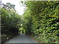
5
Deadhearn Lane
Deadhearn Lane heading down to Gorelands Lane
Image: © Shaun Ferguson
Taken: 29 Nov 2008
0.22 miles