IMAGES TAKEN NEAR TO
High Street, CHALFONT ST. GILES, HP8 4QY
Introduction
This page details the photographs taken nearby to High Street, HP8 4QY by members of the Geograph project.
The Geograph project started in 2005 with the aim of publishing, organising and preserving representative images for every square kilometre of Great Britain, Ireland and the Isle of Man.

There are currently over 7.5m images from over14,400 individuals and you can help contribute to the project by visiting https://www.geograph.org.uk
Image Map
Images are licensed for reuse under creativecommons.org/licenses/by-sa/2.0
Notes
- Clicking on the map will re-center to the selected point.
- The higher the marker number, the further away the image location is from the centre of the postcode.
Image Listing (152 Images Found)
Images are licensed for reuse under creativecommons.org/licenses/by-sa/2.0
Image
Details
Distance
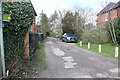
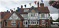
3
Wellington Cottage and Green Cottage, Chalfont St Giles
Image: © Alexander P Kapp
Taken: 2 Feb 2013
0.03 miles
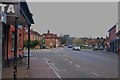
4
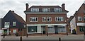
Chalfont St Giles - Shops
Near the village green.
Image: © Christine Matthews
Taken: 29 Aug 2021
0.03 miles
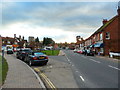
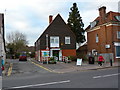
6
Chalfont St Giles
Looking towards Merlin's Cave.
Image: © Christine Matthews
Taken: 29 Aug 2021
0.04 miles
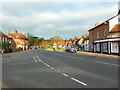
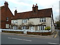
9
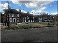
Buildings in High Street, Chalfont St Giles
This photo shows houses and shops on the north side of the High Street, its postcode being HP8 4QA. The Green can be seen in the foreground.
Image: © David Haines
Taken: 24 Aug 2022
0.04 miles