IMAGES TAKEN NEAR TO
Gorelands Lane, CHALFONT ST. GILES, HP8 4HQ
Introduction
This page details the photographs taken nearby to Gorelands Lane, HP8 4HQ by members of the Geograph project.
The Geograph project started in 2005 with the aim of publishing, organising and preserving representative images for every square kilometre of Great Britain, Ireland and the Isle of Man.

There are currently over 7.5m images from over14,400 individuals and you can help contribute to the project by visiting https://www.geograph.org.uk
Image Map
Images are licensed for reuse under creativecommons.org/licenses/by-sa/2.0
Notes
- Clicking on the map will re-center to the selected point.
- The higher the marker number, the further away the image location is from the centre of the postcode.
Image Listing (25 Images Found)
Images are licensed for reuse under creativecommons.org/licenses/by-sa/2.0
Image
Details
Distance
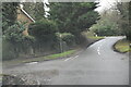
7
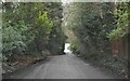
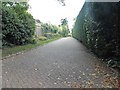
Chalfont St Giles: Deadhearn Lane
This is the view from just north of the junction with Gorelands Lane. Deadhearn Wood used to be to the left, but has been taken over by private housing.
Image: © Nigel Cox
Taken: 22 May 2011
0.12 miles
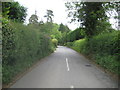
8
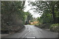
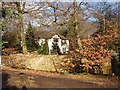
Deadhearn Lane, Chalfont St Giles
The houses are all hiding behind the trees
Image: © David Howard
Taken: 8 Oct 2015
0.13 miles
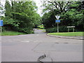
9
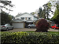
Barrington Park Gardens, Chalfont St Giles
Image: © David Howard
Taken: 8 Oct 2015
0.13 miles
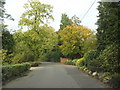
10
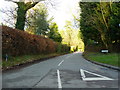
King's Road byway, Chalfont St Giles
This short stretch continuing King's Road is a public byway. Photo from Gorlands Lane.
Image: © David Hawgood
Taken: 17 Feb 2006
0.13 miles