IMAGES TAKEN NEAR TO
Bottom House Farm Lane, CHALFONT ST. GILES, HP8 4EE
Introduction
This page details the photographs taken nearby to Bottom House Farm Lane, HP8 4EE by members of the Geograph project.
The Geograph project started in 2005 with the aim of publishing, organising and preserving representative images for every square kilometre of Great Britain, Ireland and the Isle of Man.

There are currently over 7.5m images from over14,400 individuals and you can help contribute to the project by visiting https://www.geograph.org.uk
Image Map
Images are licensed for reuse under creativecommons.org/licenses/by-sa/2.0
Notes
- Clicking on the map will re-center to the selected point.
- The higher the marker number, the further away the image location is from the centre of the postcode.
Image Listing (24 Images Found)
Images are licensed for reuse under creativecommons.org/licenses/by-sa/2.0
Image
Details
Distance
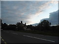
1
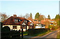
Houses on Bottom House Farm Lane
These have nice views over the Misbourne valley. At the top of the road is the A413.
Image: © Graham Horn
Taken: 16 Jan 2012
0.00 miles
2
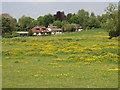
Houses in Bottom House Farm Lane, Chalfont St Giles
View from public footpath across a pasture field with buttercups.
Image: © David Hawgood
Taken: 22 May 2008
0.01 miles
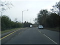
4
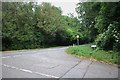
Mill Lane at the junction of Amersham Road
Image: © David Howard
Taken: 11 Jun 2020
0.05 miles
5
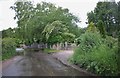
Ford across the Misbourne, Little Chalfont
Image: © David Howard
Taken: 11 Jun 2020
0.07 miles
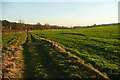
6
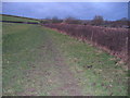
South Bucks Way
South Bucks Way heading towards Farm Lane
Image: © Shaun Ferguson
Taken: 30 May 2008
0.07 miles
7
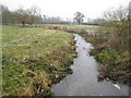
River Misbourne near Chalfont St Giles
The clear River Misbourne meanders slowly through frosted fields towards Chalfont St Giles. However downstream in the village itself Image the riverbed is dry...
Image: © Nigel Cox
Taken: 31 Dec 2008
0.07 miles
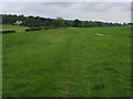
8
Footpath in the Misbourne valley
This footpath follows the first high ground to the south-west of the River Misbourne. It is used by the South Bucks Way.
Image: © Graham Horn
Taken: 16 Jan 2012
0.10 miles