IMAGES TAKEN NEAR TO
Lodge Lane, CHALFONT ST. GILES, HP8 4AJ
Introduction
This page details the photographs taken nearby to Lodge Lane, HP8 4AJ by members of the Geograph project.
The Geograph project started in 2005 with the aim of publishing, organising and preserving representative images for every square kilometre of Great Britain, Ireland and the Isle of Man.

There are currently over 7.5m images from over14,400 individuals and you can help contribute to the project by visiting https://www.geograph.org.uk
Image Map
Images are licensed for reuse under creativecommons.org/licenses/by-sa/2.0
Notes
- Clicking on the map will re-center to the selected point.
- The higher the marker number, the further away the image location is from the centre of the postcode.
Image Listing (7 Images Found)
Images are licensed for reuse under creativecommons.org/licenses/by-sa/2.0
Image
Details
Distance
2
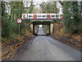
Lodge Lane
Lodge Lane heading under the Metropolitan Line railway bridge
Image: © Shaun Ferguson
Taken: 29 Nov 2008
0.14 miles
3

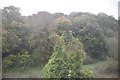
Little Chalfont from the air
The A404 Amersham Road to the east of Little Chalfont is at the bottom of the photo which was taken from a Heathrow bound flight from Glasgow.
Image: © Thomas Nugent
Taken: 9 Oct 2011
0.14 miles
6
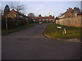
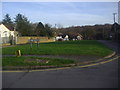
Little Chalfont: Church Grove
Church Grove on the eastern edge of Little Chalfont, viewed looking westwards, where there is a conspicuous absence of any church.
Image: © Nigel Cox
Taken: 7 Jan 2006
0.21 miles