IMAGES TAKEN NEAR TO
Lodge Lane, CHALFONT ST. GILES, HP8 4AF
Introduction
This page details the photographs taken nearby to Lodge Lane, HP8 4AF by members of the Geograph project.
The Geograph project started in 2005 with the aim of publishing, organising and preserving representative images for every square kilometre of Great Britain, Ireland and the Isle of Man.

There are currently over 7.5m images from over14,400 individuals and you can help contribute to the project by visiting https://www.geograph.org.uk
Image Map
Images are licensed for reuse under creativecommons.org/licenses/by-sa/2.0
Notes
- Clicking on the map will re-center to the selected point.
- The higher the marker number, the further away the image location is from the centre of the postcode.
Image Listing (2 Images Found)
Images are licensed for reuse under creativecommons.org/licenses/by-sa/2.0
Image
Details
Distance
1
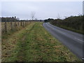
Lodge Lane
Lodge Lane heading up to Amersham Road
Image: © Shaun Ferguson
Taken: 29 Nov 2008
0.15 miles
2
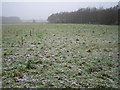
Little Chalfont: Lodge Lane
One of several greenfield sites, mainly in the South East of England, where plots of freehold land are being sold to individuals, "without current planning permission, in areas of high housing need". See link for the website of the company that is selling plots on this particular site http://www.propertyspy.co.uk/default.htm The stakes stretching away across the field presumably indicate individual plots.
Image: © Nigel Cox
Taken: 7 Jan 2006
0.17 miles