IMAGES TAKEN NEAR TO
Cokes Lane, AMERSHAM, HP7 9QD
Introduction
This page details the photographs taken nearby to Cokes Lane, HP7 9QD by members of the Geograph project.
The Geograph project started in 2005 with the aim of publishing, organising and preserving representative images for every square kilometre of Great Britain, Ireland and the Isle of Man.

There are currently over 7.5m images from over14,400 individuals and you can help contribute to the project by visiting https://www.geograph.org.uk
Image Map
Images are licensed for reuse under creativecommons.org/licenses/by-sa/2.0
Notes
- Clicking on the map will re-center to the selected point.
- The higher the marker number, the further away the image location is from the centre of the postcode.
Image Listing (86 Images Found)
Images are licensed for reuse under creativecommons.org/licenses/by-sa/2.0
Image
Details
Distance
1
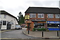
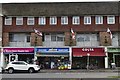
Shops on Cokes Lane, Little Chalfont
Been there, done that http://www.geograph.org.uk/photo/4484728
Image: © David Howard
Taken: 14 Apr 2018
0.02 miles
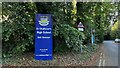
2
Little Chalfont Community Library
Taken from Coke's Lane (B 4442). This is now run very effectively as a Community Library.
Image: © Clint Mann
Taken: 20 Aug 2012
0.02 miles
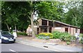
4
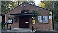
Little Chalfont Parish Council, Cokes Lane
Image: © Bryn Holmes
Taken: 17 Oct 2023
0.03 miles
5
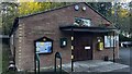
Little Chalfont Parish Council, Cokes Lane
Image: © Bryn Holmes
Taken: 17 Oct 2023
0.03 miles
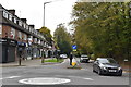
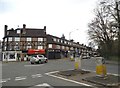
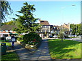
7
Little Chalfont: Nightingales Corner
Community shops on the A404 road.
Image: © Nigel Cox
Taken: 7 Jan 2006
0.04 miles
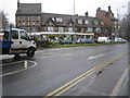
9
Nightingales Corner, Little Chalfont
Looking west along Chalfont Station Road past the Burton's Lane junction.
Image: © Jonathan Billinger
Taken: 1 Oct 2008
0.05 miles