IMAGES TAKEN NEAR TO
Lincoln Park, AMERSHAM, HP7 9HF
Introduction
This page details the photographs taken nearby to Lincoln Park, HP7 9HF by members of the Geograph project.
The Geograph project started in 2005 with the aim of publishing, organising and preserving representative images for every square kilometre of Great Britain, Ireland and the Isle of Man.

There are currently over 7.5m images from over14,400 individuals and you can help contribute to the project by visiting https://www.geograph.org.uk
Image Map
Images are licensed for reuse under creativecommons.org/licenses/by-sa/2.0
Notes
- Clicking on the map will re-center to the selected point.
- The higher the marker number, the further away the image location is from the centre of the postcode.
Image Listing (21 Images Found)
Images are licensed for reuse under creativecommons.org/licenses/by-sa/2.0
Image
Details
Distance
1
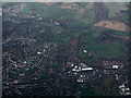
Amersham and Chesham from the air
Looking over Corinium Industrial Estate, with Chesham in the distance. Seen while circling, waiting to approach Heathrow from the east on a flight from Glasgow.
This was the second lap, see the same scene on the first lap, around five minutes earlier Image
Image: © Thomas Nugent
Taken: 24 Nov 2014
0.11 miles
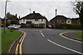
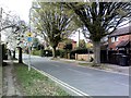
3
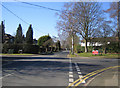
Amersham: Stanley Hill Avenue
Viewed looking westwards at the junction with Highland Road to the right and Acres End to the left.
Image: © Nigel Cox
Taken: 4 Mar 2006
0.17 miles
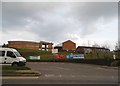
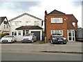
4
Junction of Stanley Hill and Stanley Hill Avenue
Image: © David Howard
Taken: 4 Oct 2011
0.17 miles
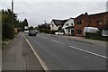
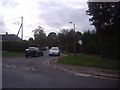
9
Highland Road, Amersham
Looking up Highland Road from Stanley Hill Avenue. The road forms part of the Milton Route cycle route, so a reassurance shield is there.
Image: © Simon Hollett
Taken: 3 Apr 2014
0.19 miles
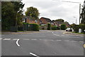
10
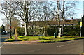
Amersham Common
To the right is Highland Road, one of a network of roads leading to larger properties south of the railway line.
Image: © Graham Horn
Taken: 16 Jan 2012
0.20 miles