IMAGES TAKEN NEAR TO
Lincoln Park, AMERSHAM, HP7 9HD
Introduction
This page details the photographs taken nearby to Lincoln Park, HP7 9HD by members of the Geograph project.
The Geograph project started in 2005 with the aim of publishing, organising and preserving representative images for every square kilometre of Great Britain, Ireland and the Isle of Man.

There are currently over 7.5m images from over14,400 individuals and you can help contribute to the project by visiting https://www.geograph.org.uk
Image Map
Images are licensed for reuse under creativecommons.org/licenses/by-sa/2.0
Notes
- Clicking on the map will re-center to the selected point.
- The higher the marker number, the further away the image location is from the centre of the postcode.
Image Listing (30 Images Found)
Images are licensed for reuse under creativecommons.org/licenses/by-sa/2.0
Image
Details
Distance
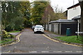
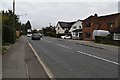
3
Junction of Stanley Hill and Stanley Hill Avenue
Image: © David Howard
Taken: 4 Oct 2011
0.15 miles


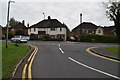
7
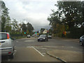
Roundabout on Stanley Hill, Amersham
The road on the left goes under the Metropolitan Line railway bridge into town.
Image: © David Howard
Taken: 4 Oct 2011
0.16 miles
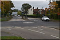
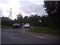
9
Stanley Hill at the junction of Woodside Road
Image: © David Howard
Taken: 4 Oct 2011
0.16 miles