IMAGES TAKEN NEAR TO
London Road East, AMERSHAM, HP7 9DP
Introduction
This page details the photographs taken nearby to London Road East, HP7 9DP by members of the Geograph project.
The Geograph project started in 2005 with the aim of publishing, organising and preserving representative images for every square kilometre of Great Britain, Ireland and the Isle of Man.

There are currently over 7.5m images from over14,400 individuals and you can help contribute to the project by visiting https://www.geograph.org.uk
Image Map (Loading...)


Getting Data...Please wait
Leaflet Map data © OpenStreetMap
Images are licensed for reuse under creativecommons.org/licenses/by-sa/2.0
Notes
- Clicking on the map will re-center to the selected point.
- The higher the marker number, the further away the image location is from the centre of the postcode.
Image Listing (9 Images Found)
Images are licensed for reuse under creativecommons.org/licenses/by-sa/2.0
Image
Details
Distance
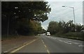
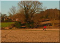
3
Quarrendon Mill, near Amersham
Converted as housing. Photo looking north-east from footpath.
Image: © David Hawgood
Taken: 30 Jan 2006
0.17 miles
4
Quarrendon Mill
A former water mill on the River Misbourne, now housing.
Image: © Graham Horn
Taken: 16 Jan 2012
0.17 miles
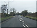
5
South Bucks Way
South Bucks Way heading up past Quarrendon Mill
Image: © Shaun Ferguson
Taken: 30 May 2008
0.18 miles
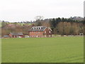
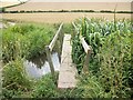
6
Walking across to the Misbourne
This dog walker is taking the cross-field path towards a bridge over the River Misbourne, that leads to London Road (A413).
Image: © Graham Horn
Taken: 16 Jan 2012
0.23 miles
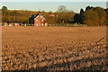
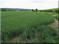
8
Track to Quarrendon Farm near Amersham, with winter wheat
Looking south west from the valley near the River Misbourne, up through fields of winter wheat.
Image: © David Hawgood
Taken: 30 Jan 2006
0.24 miles
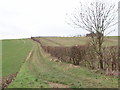
9

Farmland, Amersham
A footpath crossing an arable field to the south of the River Misbourne.
Image: © Andrew Smith
Taken: 17 Dec 2022
0.24 miles