IMAGES TAKEN NEAR TO
Mop End, AMERSHAM, HP7 0QP
Introduction
This page details the photographs taken nearby to HP7 0QP by members of the Geograph project.
The Geograph project started in 2005 with the aim of publishing, organising and preserving representative images for every square kilometre of Great Britain, Ireland and the Isle of Man.

There are currently over 7.5m images from over14,400 individuals and you can help contribute to the project by visiting https://www.geograph.org.uk
Image Map
Images are licensed for reuse under creativecommons.org/licenses/by-sa/2.0
Notes
- Clicking on the map will re-center to the selected point.
- The higher the marker number, the further away the image location is from the centre of the postcode.
Image Listing (8 Images Found)
Images are licensed for reuse under creativecommons.org/licenses/by-sa/2.0
Image
Details
Distance
1
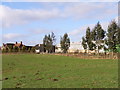
Mop End Farm
From the public footpath to the south.
Image: © Andrew Smith
Taken: 9 Apr 2006
0.04 miles
2
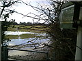
Partly-flooded public footpath off Mop End Lane
Image: © Peter S
Taken: 7 Feb 2014
0.05 miles
3
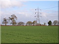
Farmland at Mop End
The more northerly of the two lines of pylons in the vicinity. The two visible are both in the grid-square.
Image: © Andrew Smith
Taken: 9 Apr 2006
0.10 miles
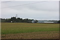
5
Woodland near Mop End
Footpath heading back towards the hamlet.
Image: © Andrew Smith
Taken: 8 Apr 2006
0.17 miles
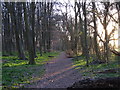
6
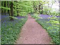
Path through wood at Mop End
Bluebells in beech wood at springtime
Image: © michael
Taken: 4 May 2009
0.18 miles
7
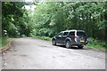
Mop End Lane
Leading to the Field Studies Centre in the woods
Image: © David Howard
Taken: 11 Jun 2020
0.21 miles
8
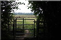
Mop End footpath gate
The footpath from Toby's Lane towards Mop End.
Image: © Robert Eva
Taken: 8 Oct 2016
0.22 miles