IMAGES TAKEN NEAR TO
Chancellors, AMERSHAM, HP7 0QN
Introduction
This page details the photographs taken nearby to Chancellors, HP7 0QN by members of the Geograph project.
The Geograph project started in 2005 with the aim of publishing, organising and preserving representative images for every square kilometre of Great Britain, Ireland and the Isle of Man.

There are currently over 7.5m images from over14,400 individuals and you can help contribute to the project by visiting https://www.geograph.org.uk
Image Map
Images are licensed for reuse under creativecommons.org/licenses/by-sa/2.0
Notes
- Clicking on the map will re-center to the selected point.
- The higher the marker number, the further away the image location is from the centre of the postcode.
Image Listing (34 Images Found)
Images are licensed for reuse under creativecommons.org/licenses/by-sa/2.0
Image
Details
Distance
1
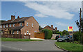
Chancellors at Chancellors
What are the odds of that? An estate agents called Chancellors are selling a place on the corner of a street called Chancellors.
A short residential cul de sac off Penn Street. Chancellors Corner is nearby along the main road.
Image: © Des Blenkinsopp
Taken: 10 Aug 2023
0.03 miles
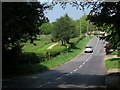
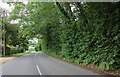
3
Road out from Penn Street to the A404
Road by the Church out from Penn Street to the A404
Image: © Shaun Ferguson
Taken: 22 Mar 2008
0.04 miles
5
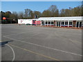
Curzon Church of England Combined School, Penn Street(2)
This photo shows the playground and school buildings looking West towards the road to Penn Street. The red school board can be seen to the left of the photo.
Image: © David Hillas
Taken: 6 Apr 2017
0.07 miles
6
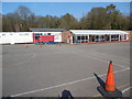
Curzon Church of England Combined School, Penn Street (1)
Situated in School Lane HP7 0QL, this school admits children between four years and eleven years old. This photo shows the playground with the school buildings behind it.
Image: © David Hillas
Taken: 6 Apr 2017
0.07 miles
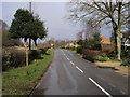
7
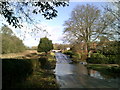
Flood in the road at Penn Street
The parish of Penn includes the village of Penn and the hamlets of Penn Street, Knotty Green and Forty Green, plus Winchmore Hill covering an area of 3,991 acres.
Image: © Peter S
Taken: 7 Feb 2014
0.07 miles
8
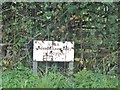
CEGB cable warning sign on Penn Street
Issued by the Central Electricity Generating Board which was created in 1957 and disbanded with privatisation in around 1997 https://en.wikipedia.org/wiki/Central_Electricity_Generating_Board
Image: © David Howard
Taken: 8 Oct 2015
0.08 miles
10
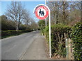
Crossing Point Sign near Penn Street
This photo shows a crossing point sign North of Penn Street for children going to and from Curzon Church of England Combined School nearby.
Image: © David Hillas
Taken: 6 Apr 2017
0.09 miles