IMAGES TAKEN NEAR TO
Woodrow, AMERSHAM, HP7 0QH
Introduction
This page details the photographs taken nearby to HP7 0QH by members of the Geograph project.
The Geograph project started in 2005 with the aim of publishing, organising and preserving representative images for every square kilometre of Great Britain, Ireland and the Isle of Man.

There are currently over 7.5m images from over14,400 individuals and you can help contribute to the project by visiting https://www.geograph.org.uk
Image Map
Images are licensed for reuse under creativecommons.org/licenses/by-sa/2.0
Notes
- Clicking on the map will re-center to the selected point.
- The higher the marker number, the further away the image location is from the centre of the postcode.
Image Listing (4 Images Found)
Images are licensed for reuse under creativecommons.org/licenses/by-sa/2.0
Image
Details
Distance
2
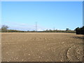
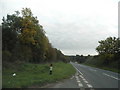
Farmland at Woodrow
Electricity cables passing to the west of the hamlet.
Image: © Andrew Smith
Taken: 9 Apr 2006
0.15 miles
3
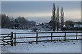
Pasture, Amersham
Paddocks at Woodrow in the snow that had fallen two days earlier.
Image: © Andrew Smith
Taken: 13 Dec 2022
0.15 miles
4
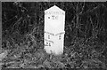
Old Milepost by the A404, Woodrow, Amersham Parish
Wilder gabled iron casting by the A404, in parish of Amersham (Chiltern District), roadside, by the road.
Inscription reads:- : WYCOMBE / 5 / READING / 24 : : AMERSHAM / 2 : : HATFIELD / 26 :
Lost since 1970.
Milestone Society National ID: BU_RGHT24
Image: © Milestone Society
Taken: Unknown
0.19 miles