IMAGES TAKEN NEAR TO
Whielden Lane, AMERSHAM, HP7 0NF
Introduction
This page details the photographs taken nearby to Whielden Lane, HP7 0NF by members of the Geograph project.
The Geograph project started in 2005 with the aim of publishing, organising and preserving representative images for every square kilometre of Great Britain, Ireland and the Isle of Man.

There are currently over 7.5m images from over14,400 individuals and you can help contribute to the project by visiting https://www.geograph.org.uk
Image Map (6 Images)


Leaflet Map data © OpenStreetMap
Images are licensed for reuse under creativecommons.org/licenses/by-sa/2.0
Notes
- Clicking on the map will re-center to the selected point.
- The higher the marker number, the further away the image location is from the centre of the postcode.
Image Listing (6 Images Found)
Images are licensed for reuse under creativecommons.org/licenses/by-sa/2.0
Image
Details
Distance
1

Long Meadow Close, Winchmore Hill
Recently built houses using traditional brick and flint work.
Image: © Des Blenkinsopp
Taken: 10 Aug 2023
0.12 miles
2
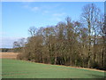
Beeches near Winchmore Hill
With Tragoe's Plantation beyond.
Image: © Andrew Smith
Taken: 9 Apr 2006
0.17 miles
3
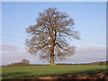
Farmland and tree near Winchmore Hill
From the edge of Coleshill Larches.
Image: © Andrew Smith
Taken: 9 Apr 2006
0.17 miles
4
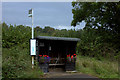
Winchmore Hill bus shelter with flowers
This is the shelter for Eastbound buses
Image: © Robert Eva
Taken: 8 Oct 2016
0.22 miles
5
Chiltern Way between Winchmore Hill and Coleshill
Image: © Robert Eva
Taken: 8 Oct 2016
0.23 miles
6
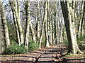
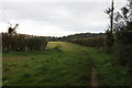
Track and beeches, near Winchmore Hill
The track, a public footpath, is lined with beeches. There is a small plantation of young conifers alongside.
Image: © Andrew Smith
Taken: 9 Apr 2006
0.23 miles