IMAGES TAKEN NEAR TO
Station Road, AMERSHAM, HP7 0AT
Introduction
This page details the photographs taken nearby to Station Road, HP7 0AT by members of the Geograph project.
The Geograph project started in 2005 with the aim of publishing, organising and preserving representative images for every square kilometre of Great Britain, Ireland and the Isle of Man.

There are currently over 7.5m images from over14,400 individuals and you can help contribute to the project by visiting https://www.geograph.org.uk
Image Map
Images are licensed for reuse under creativecommons.org/licenses/by-sa/2.0
Notes
- Clicking on the map will re-center to the selected point.
- The higher the marker number, the further away the image location is from the centre of the postcode.
Image Listing (125 Images Found)
Images are licensed for reuse under creativecommons.org/licenses/by-sa/2.0
Image
Details
Distance
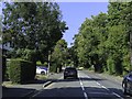
1
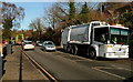
Bin day on Station Road
This is within the Chiltern District Council area, the second tier local authority that is responsible for street waste collection. Councils normally ask that the bins are left by the kerbside, as here, and that they must be completely closed, i.e. not overflowing, unlike here. Landfill waste, usually in black bins, is usually collected once every two weeks, with recycling and/or green waste collected during the opposite week.
However it appears that here the collections are on the same day, so we had lorries going in opposite directions causing quite a bottleneck on this busy road. The white lorry, collecting green waste, is operated by a contractor Verdant.
Image: © Graham Horn
Taken: 16 Jan 2012
0.02 miles
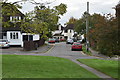
2
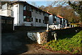
Parsonage Place
These are probably apartments and probably built in the 1930s. They retain a hint of art-deco 1920s features but also have tile-clad bay windows typical of the 1940s. Alternatively they are much newer, 1980s, and haven't worn well.
Image: © Graham Horn
Taken: 16 Jan 2012
0.08 miles
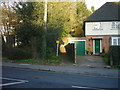
3

Victorian postbox on Station Road, Amersham
Postbox No. HP7 65.
See Image] for context.
Image: © JThomas
Taken: 13 Apr 2019
0.10 miles
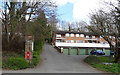
4
Quickberry Place, Amersham
Houses set on a hillside off Station Road.
Image: © JThomas
Taken: 13 Apr 2019
0.12 miles
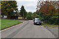
5
Quickberry Place, Amersham
Showing position of Postbox No. HP7 65.
See Image] for postbox.
Image: © JThomas
Taken: 13 Apr 2019
0.12 miles
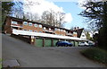
8
Public Footpath from Station Road
This enclosed path goes steeply uphill and east to come out onto Stanley Hill Avenue at Amersham Common. This is on the route of the London Green Belt Way.
Image: © Sean Davis
Taken: 13 Mar 2011
0.14 miles
10
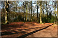
Parsonage Wood
A welcome relief to the busy Station Road just to the east. I'll bet this is popular dog-walking territory.
Image: © Graham Horn
Taken: 16 Jan 2012
0.14 miles