IMAGES TAKEN NEAR TO
Woodside Avenue, AMERSHAM, HP6 6EG
Introduction
This page details the photographs taken nearby to Woodside Avenue, HP6 6EG by members of the Geograph project.
The Geograph project started in 2005 with the aim of publishing, organising and preserving representative images for every square kilometre of Great Britain, Ireland and the Isle of Man.

There are currently over 7.5m images from over14,400 individuals and you can help contribute to the project by visiting https://www.geograph.org.uk
Image Map
Images are licensed for reuse under creativecommons.org/licenses/by-sa/2.0
Notes
- Clicking on the map will re-center to the selected point.
- The higher the marker number, the further away the image location is from the centre of the postcode.
Image Listing (6 Images Found)
Images are licensed for reuse under creativecommons.org/licenses/by-sa/2.0
Image
Details
Distance
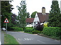
2
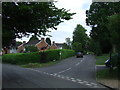
Amersham: Chestnut Lane
Houses to the east of the Red Lion Public House.
Image: © Nigel Cox
Taken: 4 Mar 2006
0.20 miles
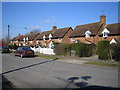
5
St. Leonard's Road, Chesham Bois
Modern housing in Chesham Bois. Although the road does not have street lighting, signs indicate that the 30mph speed limit applies nevertheless.
Image: © Malc McDonald
Taken: 4 Jun 2011
0.23 miles
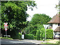
6
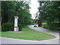
Chesham Bois War Memorial
A war memorial in the village of Chesham Bois in Buckinghamshire.
Image: © Malc McDonald
Taken: 4 Jun 2011
0.24 miles