IMAGES TAKEN NEAR TO
High Bois Lane, AMERSHAM, HP6 6DG
Introduction
This page details the photographs taken nearby to High Bois Lane, HP6 6DG by members of the Geograph project.
The Geograph project started in 2005 with the aim of publishing, organising and preserving representative images for every square kilometre of Great Britain, Ireland and the Isle of Man.

There are currently over 7.5m images from over14,400 individuals and you can help contribute to the project by visiting https://www.geograph.org.uk
Image Map
Images are licensed for reuse under creativecommons.org/licenses/by-sa/2.0
Notes
- Clicking on the map will re-center to the selected point.
- The higher the marker number, the further away the image location is from the centre of the postcode.
Image Listing (36 Images Found)
Images are licensed for reuse under creativecommons.org/licenses/by-sa/2.0
Image
Details
Distance
2
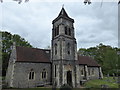
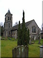
St. Leonard's Church, Chesham Bois
St. Leonard's Church, in the village of Chesham Bois, dates from the 13th Century although the building has been extensively altered since then.
Image: © Malc McDonald
Taken: 4 Jun 2011
0.04 miles
5
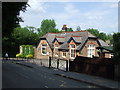
Chesham Bois School
A Church of England primary school in the village of Chesham Bois, Buckinghamshire.
Image: © Malc McDonald
Taken: 4 Jun 2011
0.08 miles
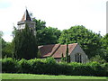
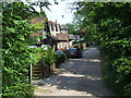
6
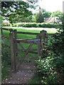
Footpath gate, Chesham Bois
A footpath leads from this gate to St. Leonard's Church, visible in the background.
Image: © Malc McDonald
Taken: 4 Jun 2011
0.09 miles
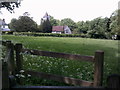
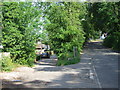
7
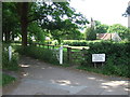
Driveway and footpath, Chesham Bois
A private driveway leading off Bois Lane in Chesham Bois. Between the white gatepost and the sign is another wooden gate, for a footpath leading to the church (visible in the background).
Image: © Malc McDonald
Taken: 4 Jun 2011
0.10 miles
8
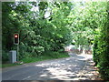
Bois Lane, Chesham Bois
As it bends sharply to the left, Bois Lane crosses a narrow bridge over London Underground's Metropolitan Line. As there is no space for vehicles to pass nor can drivers see oncoming traffic, traffic lights have been installed to control the flow of traffic onto the bridge.
Image: © Malc McDonald
Taken: 4 Jun 2011
0.12 miles
9
Bois Hill and Bois Moor Road, Chesham
Bois Hill, on the left, is an unmade road providing access to a row of houses. Bois Moor Road, on the right, bends round to the right to cross a narrow bridge over the railway. The bridge is too narrow for vehicles to pass, but the bend in the road means that drivers cannot see oncoming traffic. Traffic lights have therefore been provided to control the flow of traffic across the bridge.
Image: © Malc McDonald
Taken: 4 Jun 2011
0.14 miles
10
Bois Hill, Chesham
Bois Hill is an unmade cul-de-sac to a row of houses near Chesham, Buckinghamshire.
Image: © Malc McDonald
Taken: 4 Jun 2011
0.15 miles