IMAGES TAKEN NEAR TO
Ashdown Way, AMERSHAM, HP6 6BD
Introduction
This page details the photographs taken nearby to Ashdown Way, HP6 6BD by members of the Geograph project.
The Geograph project started in 2005 with the aim of publishing, organising and preserving representative images for every square kilometre of Great Britain, Ireland and the Isle of Man.

There are currently over 7.5m images from over14,400 individuals and you can help contribute to the project by visiting https://www.geograph.org.uk
Image Map
Images are licensed for reuse under creativecommons.org/licenses/by-sa/2.0
Notes
- Clicking on the map will re-center to the selected point.
- The higher the marker number, the further away the image location is from the centre of the postcode.
Image Listing (26 Images Found)
Images are licensed for reuse under creativecommons.org/licenses/by-sa/2.0
Image
Details
Distance
2
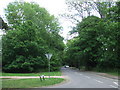
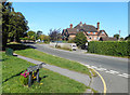
Sycamore Road, Amersham
Sycamore Road, where it leaves Amersham and enters Chesham Bois.
Image: © Malc McDonald
Taken: 4 Jun 2011
0.16 miles
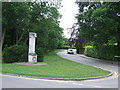
3
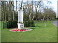
Chesham Bois: The War Memorial
The memorial, which is of a rather unusual design, is at the north eastern end of Chesham Bois Common. Some yew trees have recently been planted to provide a backdrop. To the right is North Road.
Image: © Nigel Cox
Taken: 19 Mar 2008
0.18 miles
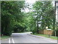
4
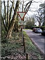
Glebe Way, Chesham Bois
Glebe Way in Chesham Bois. The sign indicates that this is a route for large goods vehicles, to reach Chesham avoiding a weight restriction. The small blue sign shows that this road is also part of a network of cycle routes.
Image: © Malc McDonald
Taken: 4 Jun 2011
0.18 miles
5
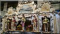
Amersham Fair Organ Museum
One of the historic fair organs in the collection of Ted Reed. The museum opens once a month in winter.
Image: © Mark Percy
Taken: 7 Jan 2018
0.19 miles
6
South Road, Amersham
Running along the south side of Chesham Bois Common, South Road is in Amersham. It would be a rather rural roadscape if it was not for all the parked cars.
Image: © Simon Hollett
Taken: 3 Apr 2014
0.20 miles
7
Chesham Bois War Memorial
A war memorial in the village of Chesham Bois in Buckinghamshire.
Image: © Malc McDonald
Taken: 4 Jun 2011
0.20 miles
8
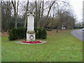
Chesham Bois War Memorial
Chesham Bois War Memorial on the corner of North Road and Bois Lane
Image: © Shaun Ferguson
Taken: 29 Nov 2008
0.21 miles
9
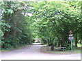
Grimsdell's Lane, Amersham
Junction with Green Lane.
Image: © Des Blenkinsopp
Taken: 13 Sep 2018
0.22 miles
10
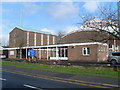
Former St John's Methodist Church, Amersham (1)
Situated in Woodside Road, this church was opened in 1960 and is one of nine churches in the Amersham Methodist Circuit. It was called St John's, since a large amount of money for the new church buildings came from compensation for bomb damage in World War II following the destruction of the Methodist Church in St John's Square, Clerkenwell, London. The postcode of this church is HP6 6AJ. Update: the final service at this church was held at 3.00pm on Sunday 17th April 2022.
Image: © David Hillas
Taken: 16 Feb 2011
0.22 miles