IMAGES TAKEN NEAR TO
Redding Drive, AMERSHAM, HP6 5PX
Introduction
This page details the photographs taken nearby to Redding Drive, HP6 5PX by members of the Geograph project.
The Geograph project started in 2005 with the aim of publishing, organising and preserving representative images for every square kilometre of Great Britain, Ireland and the Isle of Man.

There are currently over 7.5m images from over14,400 individuals and you can help contribute to the project by visiting https://www.geograph.org.uk
Image Map
Images are licensed for reuse under creativecommons.org/licenses/by-sa/2.0
Notes
- Clicking on the map will re-center to the selected point.
- The higher the marker number, the further away the image location is from the centre of the postcode.
Image Listing (9 Images Found)
Images are licensed for reuse under creativecommons.org/licenses/by-sa/2.0
Image
Details
Distance
2
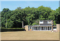
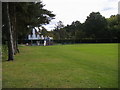
Pavilion in Hervines Park
The Summer 2018 drought has left the grass looking parched.
Image: © Des Blenkinsopp
Taken: 6 Aug 2018
0.12 miles
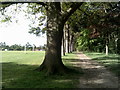
4
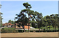
Pines in the Park
The edge of Hervines Park, a playing field on the west side of Amersham.
Image: © Des Blenkinsopp
Taken: 6 Aug 2018
0.18 miles
5
Hervines Park
Hervines Park with children's playground
Image: © Shaun Ferguson
Taken: 3 Oct 2008
0.21 miles
7
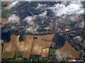
Amersham from the air
Allen's Barn Farm can be seen near the centre of the photo which was taken from a Heathrow bound flight from Glasgow.
Image: © Thomas Nugent
Taken: 9 Oct 2011
0.23 miles
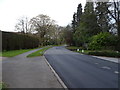
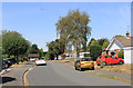
9
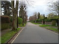
Devonshire Avenue, Amersham
Looking north west.
Image: © JThomas
Taken: 13 Apr 2019
0.24 miles