IMAGES TAKEN NEAR TO
Long Park Way, AMERSHAM, HP6 5JZ
Introduction
This page details the photographs taken nearby to Long Park Way, HP6 5JZ by members of the Geograph project.
The Geograph project started in 2005 with the aim of publishing, organising and preserving representative images for every square kilometre of Great Britain, Ireland and the Isle of Man.

There are currently over 7.5m images from over14,400 individuals and you can help contribute to the project by visiting https://www.geograph.org.uk
Image Map
Images are licensed for reuse under creativecommons.org/licenses/by-sa/2.0
Notes
- Clicking on the map will re-center to the selected point.
- The higher the marker number, the further away the image location is from the centre of the postcode.
Image Listing (25 Images Found)
Images are licensed for reuse under creativecommons.org/licenses/by-sa/2.0
Image
Details
Distance
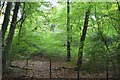
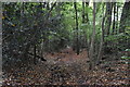
4
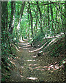
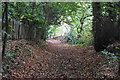
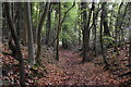
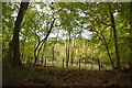
Green Lane in Bois Wood
A sunken bridleway runs through woodland down a dry valley from Chesham Bois at the top to near the River Chess at the bottom.
Image: © Des Blenkinsopp
Taken: 6 Aug 2018
0.08 miles
9
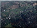
Chesham Bois and Amersham from the Air
Looking over Chesham Bois in the foreground, Waterside is on the left. Seen while circling, waiting to approach Heathrow from the east on a flight from Glasgow.
Image: © Thomas Nugent
Taken: 24 Nov 2014
0.16 miles
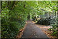
10
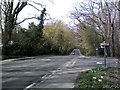
A416 Chesham Bois 1
A416 Chesham Road at North Road, Chesham Bois
Image: © Simon Hollett
Taken: 3 Apr 2014
0.16 miles