IMAGES TAKEN NEAR TO
The Vale, CHESHAM, HP5 3NU
Introduction
This page details the photographs taken nearby to The Vale, HP5 3NU by members of the Geograph project.
The Geograph project started in 2005 with the aim of publishing, organising and preserving representative images for every square kilometre of Great Britain, Ireland and the Isle of Man.

There are currently over 7.5m images from over14,400 individuals and you can help contribute to the project by visiting https://www.geograph.org.uk
Image Map
Images are licensed for reuse under creativecommons.org/licenses/by-sa/2.0
Notes
- Clicking on the map will re-center to the selected point.
- The higher the marker number, the further away the image location is from the centre of the postcode.
Image Listing (10 Images Found)
Images are licensed for reuse under creativecommons.org/licenses/by-sa/2.0
Image
Details
Distance
2
Nut Hazel Cross Farm, face in the window
Image: © Robert Eva
Taken: 24 Jun 2017
0.02 miles
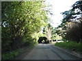
3
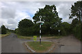
Junction of Vale Road and the road to Tring
Image: © Robert Eva
Taken: 24 Jun 2017
0.02 miles
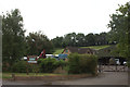
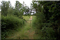
5
Nut Hazel Cross Farm, Chesham Vale
View from footpath which goes from the road up past the farm buildings.
Image: © David Hawgood
Taken: 14 Jun 2006
0.05 miles
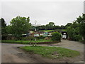
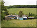
6
Pumping station, Chesham Vale
Near Nut Hazel Cross Farm
Image: © David Hawgood
Taken: 14 Jun 2006
0.05 miles
7
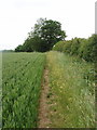
Wheat field, Chesham Vale
A footpath runs at the edge of the field, above Nut Hazel Cross Farm
Image: © David Hawgood
Taken: 14 Jun 2006
0.14 miles
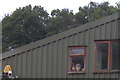
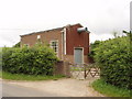
8
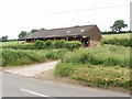
Farm building, Chesham Vale
By the road near Nut Hazel Cross Farm
Image: © David Hawgood
Taken: 14 Jun 2006
0.14 miles