IMAGES TAKEN NEAR TO
Lycrome Road, CHESHAM, HP5 3LF
Introduction
This page details the photographs taken nearby to Lycrome Road, HP5 3LF by members of the Geograph project.
The Geograph project started in 2005 with the aim of publishing, organising and preserving representative images for every square kilometre of Great Britain, Ireland and the Isle of Man.

There are currently over 7.5m images from over14,400 individuals and you can help contribute to the project by visiting https://www.geograph.org.uk
Image Map
Images are licensed for reuse under creativecommons.org/licenses/by-sa/2.0
Notes
- Clicking on the map will re-center to the selected point.
- The higher the marker number, the further away the image location is from the centre of the postcode.
Image Listing (6 Images Found)
Images are licensed for reuse under creativecommons.org/licenses/by-sa/2.0
Image
Details
Distance
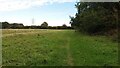
1
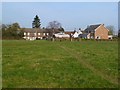
Pasture and houses, Lye Green, Chesham
With the footpath approaching from Brockhurst Farm.
Image: © Andrew Smith
Taken: 4 Feb 2012
0.03 miles
3
Footpath CM65
The little footpath sign informs us that this is Footpath CM65 to Hilltop and Lye Green Road. It is quite an overgrown example !
Image: © Rob Farrow
Taken: 16 Jun 2006
0.15 miles
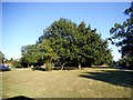
4
Henry Mash Court, Lye Green
This is a recent residential conversion of Lyegreen Farm
Image: © David Howard
Taken: 10 Sep 2015
0.16 miles
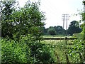
5
Path to Two Dells Lane
Beside the electric substation the Path to Two Dells Lane
Image: © Shaun Ferguson
Taken: 28 Sep 2020
0.18 miles
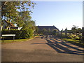
6
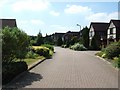
Deer Park, Lye Green
An immaculately maintained small estate of large houses in Lye Green, backing onto Lye Green Farm.
Image: © Rob Farrow
Taken: 16 Jun 2006
0.24 miles