IMAGES TAKEN NEAR TO
Nashleigh Hill, CHESHAM, HP5 3JX
Introduction
This page details the photographs taken nearby to Nashleigh Hill, HP5 3JX by members of the Geograph project.
The Geograph project started in 2005 with the aim of publishing, organising and preserving representative images for every square kilometre of Great Britain, Ireland and the Isle of Man.

There are currently over 7.5m images from over14,400 individuals and you can help contribute to the project by visiting https://www.geograph.org.uk
Image Map
Images are licensed for reuse under creativecommons.org/licenses/by-sa/2.0
Notes
- Clicking on the map will re-center to the selected point.
- The higher the marker number, the further away the image location is from the centre of the postcode.
Image Listing (7 Images Found)
Images are licensed for reuse under creativecommons.org/licenses/by-sa/2.0
Image
Details
Distance
3
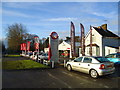
Merritts Vauxhall. Ashley Green Road, Chesham
Image: © Stacey Harris
Taken: 2 Jan 2011
0.09 miles
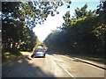
4
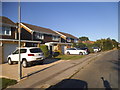
Lycrome Road at the junction of Field Close
Image: © David Howard
Taken: 10 Sep 2015
0.13 miles
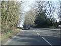
6

A416 Ashley Green Road
Heading towards Berkhamsted.
Image: © Robin Webster
Taken: 7 Jan 2018
0.16 miles
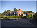
7
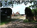
Whitethorns Farm
The signs either side of the gate seem a little schizophrenic as to whether there is a space between White and Thorn - but neither have an apostrophe before the terminal S, unlike the OS map which does !
Image: © Rob Farrow
Taken: 16 Jun 2006
0.18 miles