IMAGES TAKEN NEAR TO
Vale Road, CHESHAM, HP5 3HW
Introduction
This page details the photographs taken nearby to Vale Road, HP5 3HW by members of the Geograph project.
The Geograph project started in 2005 with the aim of publishing, organising and preserving representative images for every square kilometre of Great Britain, Ireland and the Isle of Man.

There are currently over 7.5m images from over14,400 individuals and you can help contribute to the project by visiting https://www.geograph.org.uk
Image Map
Images are licensed for reuse under creativecommons.org/licenses/by-sa/2.0
Notes
- Clicking on the map will re-center to the selected point.
- The higher the marker number, the further away the image location is from the centre of the postcode.
Image Listing (5 Images Found)
Images are licensed for reuse under creativecommons.org/licenses/by-sa/2.0
Image
Details
Distance
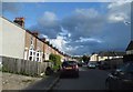
1

No Footway!
No Footway! But useful footpath running parallel to Vale Road towards Ramscote Lane
Image: © Shaun Ferguson
Taken: 21 Feb 2020
0.11 miles
2
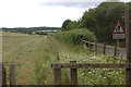
Footpath alongside Vale Road
Clearly a little-used path.
Image: © Robert Eva
Taken: 24 Jun 2017
0.13 miles
3
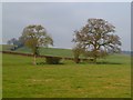
Pasture, Chesham
Oaks in a former field boundary on the western side of Chesham Vale just outside the northern edge of the town.
Image: © Andrew Smith
Taken: 4 Feb 2012
0.16 miles
4
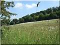
Pastureland, Chesham Vale
A sloping field full of wild flowers and grass with typical Chiltern deciduous woodland behind.
Image: © Rob Farrow
Taken: 16 Jun 2006
0.19 miles