IMAGES TAKEN NEAR TO
Abbotts Vale, CHESHAM, HP5 3HN
Introduction
This page details the photographs taken nearby to Abbotts Vale, HP5 3HN by members of the Geograph project.
The Geograph project started in 2005 with the aim of publishing, organising and preserving representative images for every square kilometre of Great Britain, Ireland and the Isle of Man.

There are currently over 7.5m images from over14,400 individuals and you can help contribute to the project by visiting https://www.geograph.org.uk
Image Map
Images are licensed for reuse under creativecommons.org/licenses/by-sa/2.0
Notes
- Clicking on the map will re-center to the selected point.
- The higher the marker number, the further away the image location is from the centre of the postcode.
Image Listing (9 Images Found)
Images are licensed for reuse under creativecommons.org/licenses/by-sa/2.0
Image
Details
Distance
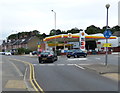
3
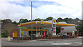
Fuel station at the bottom of Nashleigh Hill, Chesham
Image: © Robert Eva
Taken: 24 Jun 2017
0.15 miles
4
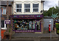
En Route shop, Berkhampstead Road, Chesham
Image: © Robert Eva
Taken: 24 Jun 2017
0.16 miles
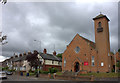
9
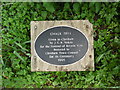
Chalk Dell Plaque by Nashleigh Hill, Chesham
Situated by the A416 Nashleigh Hill road, this plaque has the following wording:
CHALK DELL
Given to Chesham
by J.G.B.Nokes
for the Festival of Britain 1951
Restored to
Chesham Town Council
for its Centenary
1995
Image: © David Hillas
Taken: 12 May 2018
0.24 miles