IMAGES TAKEN NEAR TO
Ramscote Lane, CHESHAM, HP5 2XP
Introduction
This page details the photographs taken nearby to Ramscote Lane, HP5 2XP by members of the Geograph project.
The Geograph project started in 2005 with the aim of publishing, organising and preserving representative images for every square kilometre of Great Britain, Ireland and the Isle of Man.

There are currently over 7.5m images from over14,400 individuals and you can help contribute to the project by visiting https://www.geograph.org.uk
Image Map
Images are licensed for reuse under creativecommons.org/licenses/by-sa/2.0
Notes
- Clicking on the map will re-center to the selected point.
- The higher the marker number, the further away the image location is from the centre of the postcode.
Image Listing (6 Images Found)
Images are licensed for reuse under creativecommons.org/licenses/by-sa/2.0
Image
Details
Distance
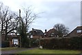
2

Path heading to Ramscote Lane
Path heading to Ramscote Lane Bellingdon
Image: © Shaun Ferguson
Taken: 21 Feb 2020
0.10 miles
3
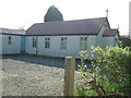
Chapel of Ease, Bellingdon
This little wooden chapel is in Bellingdon on the lane to Chesham. My gazetteer says Bellingdon is a village, but as this is its only place of worship (I think), I would have thought it was a long straggly hamlet.
Image: © Rob Farrow
Taken: 5 May 2006
0.10 miles
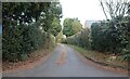
4
Huge Farm, Bellingdon
The name, not the size.
Image: © Robin Webster
Taken: 28 Jul 2017
0.15 miles
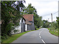
5

Half-timbered farm buildings
According to the map this is the unusually named "Huge Farm" - but I couldn't find a sign to confirm this.
Image: © Rob Farrow
Taken: 5 May 2006
0.19 miles