IMAGES TAKEN NEAR TO
Asheridge, CHESHAM, HP5 2XB
Introduction
This page details the photographs taken nearby to HP5 2XB by members of the Geograph project.
The Geograph project started in 2005 with the aim of publishing, organising and preserving representative images for every square kilometre of Great Britain, Ireland and the Isle of Man.

There are currently over 7.5m images from over14,400 individuals and you can help contribute to the project by visiting https://www.geograph.org.uk
Image Map
Images are licensed for reuse under creativecommons.org/licenses/by-sa/2.0
Notes
- Clicking on the map will re-center to the selected point.
- The higher the marker number, the further away the image location is from the centre of the postcode.
Image Listing (11 Images Found)
Images are licensed for reuse under creativecommons.org/licenses/by-sa/2.0
Image
Details
Distance
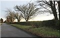
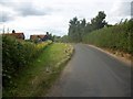
2
Road through Asheridge
A hamlet rather than a village.
Image: © Robin Webster
Taken: 28 Jul 2017
0.14 miles
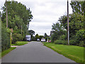
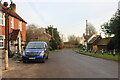
3
Tile's Farm
This farm is almost at the high point of the local hill (only 165m mind you).
Image: © Rob Farrow
Taken: 5 May 2006
0.15 miles
4
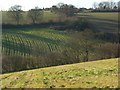
Fields below Bellingdon
The dry valley between Bellingdon and Asheridge.
Image: © Andrew Smith
Taken: 6 Dec 2008
0.15 miles
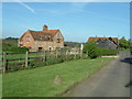
5
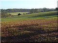
Farmland, Asheridge
The view from the edge of Widmore Wood.
Image: © Andrew Smith
Taken: 6 Dec 2008
0.17 miles
7
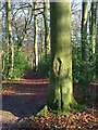
Widmore Wood, Asheridge
A footpath descending through beeches and holly.
Image: © Andrew Smith
Taken: 6 Dec 2008
0.19 miles
9
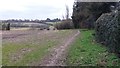
Path heading towards Chartridge
Path from Asheridge heading towards Chartridge
Image: © Shaun Ferguson
Taken: 21 Feb 2020
0.23 miles
10
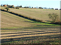
Stubble below Chartridge
The land rises quite steeply towards Asheridge.
Image: © Andrew Smith
Taken: 6 Dec 2008
0.23 miles