IMAGES TAKEN NEAR TO
Pednor, CHESHAM, HP5 2SU
Introduction
This page details the photographs taken nearby to HP5 2SU by members of the Geograph project.
The Geograph project started in 2005 with the aim of publishing, organising and preserving representative images for every square kilometre of Great Britain, Ireland and the Isle of Man.

There are currently over 7.5m images from over14,400 individuals and you can help contribute to the project by visiting https://www.geograph.org.uk
Image Map
Images are licensed for reuse under creativecommons.org/licenses/by-sa/2.0
Notes
- Clicking on the map will re-center to the selected point.
- The higher the marker number, the further away the image location is from the centre of the postcode.
Image Listing (9 Images Found)
Images are licensed for reuse under creativecommons.org/licenses/by-sa/2.0
Image
Details
Distance
1

Pednor Bottom
Midday in December, with trees casting lengthy shadows across the pasture.
Image: © Andrew Smith
Taken: 6 Dec 2008
0.05 miles
2
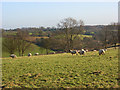
Pasture, Pednor
Sheep grazing above Pednor Bottom.
Image: © Andrew Smith
Taken: 6 Dec 2008
0.09 miles
3
Pasture, Pednor
Looking down to Pednor Bottom from the lane south of Great Pednor.
Image: © Andrew Smith
Taken: 6 Dec 2008
0.13 miles
4
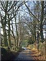
Lane at Pednor
A short avenue of trees between Great Pednor and Little Pednor.
Image: © Andrew Smith
Taken: 6 Dec 2008
0.17 miles
5
Pednor Bottom
The view of the valley from half way up the footpath climbing to Cogdells Lane, Chartridge.
Image: © Andrew Smith
Taken: 6 Dec 2008
0.20 miles
6
Pednor Bottom
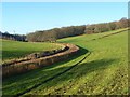
A bridleway follows the curvature of the dry valley.
Image: © Andrew Smith
Taken: 6 Dec 2008
0.21 miles
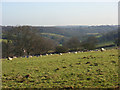
7
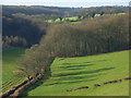
Pednor Bottom
A typical Chiltern landscape of pasture and woodland in a dry valley.
Image: © Andrew Smith
Taken: 6 Dec 2008
0.21 miles
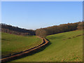
8
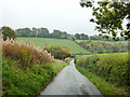
Lane descending to Pednor Bottom
At the bottom it turns right to run along the bottom.
Image: © Robin Webster
Taken: 18 Oct 2015
0.22 miles
9
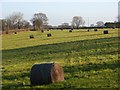
Field with bales, Pednor
Looking towards Little Pednor from the lane south of Great Pednor.
Image: © Andrew Smith
Taken: 6 Dec 2008
0.23 miles