IMAGES TAKEN NEAR TO
Westridge Close, CHESHAM, HP5 2RF
Introduction
This page details the photographs taken nearby to Westridge Close, HP5 2RF by members of the Geograph project.
The Geograph project started in 2005 with the aim of publishing, organising and preserving representative images for every square kilometre of Great Britain, Ireland and the Isle of Man.

There are currently over 7.5m images from over14,400 individuals and you can help contribute to the project by visiting https://www.geograph.org.uk
Image Map
Images are licensed for reuse under creativecommons.org/licenses/by-sa/2.0
Notes
- Clicking on the map will re-center to the selected point.
- The higher the marker number, the further away the image location is from the centre of the postcode.
Image Listing (6 Images Found)
Images are licensed for reuse under creativecommons.org/licenses/by-sa/2.0
Image
Details
Distance
2
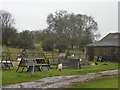
Free-range chicken run, at Sear's Barn, Pednor Road
On this rainy afternoon few of the chickens seemed to be out and about. Eggs were on offer at £1.50 per half dozen.
Image: © Stefan Czapski
Taken: 17 Mar 2013
0.19 miles
3
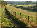
Countryside, Chesham
Looking down from the footpath above and parallel to Pednor Road.
Image: © Andrew Smith
Taken: 6 Dec 2008
0.19 miles
4
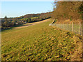
Pasture, Chesham
Beside a footpath and woodland edge above Pednor Road.
Image: © Andrew Smith
Taken: 6 Dec 2008
0.21 miles
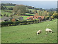
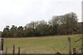
6

Rose Acre, Chesham
A view across the valley from the footpath that runs parallel with and just above Pednor Road.
Image: © Andrew Smith
Taken: 6 Dec 2008
0.24 miles