IMAGES TAKEN NEAR TO
Bottom Lane, CHESHAM, HP5 1XL
Introduction
This page details the photographs taken nearby to Bottom Lane, HP5 1XL by members of the Geograph project.
The Geograph project started in 2005 with the aim of publishing, organising and preserving representative images for every square kilometre of Great Britain, Ireland and the Isle of Man.

There are currently over 7.5m images from over14,400 individuals and you can help contribute to the project by visiting https://www.geograph.org.uk
Image Map
Images are licensed for reuse under creativecommons.org/licenses/by-sa/2.0
Notes
- Clicking on the map will re-center to the selected point.
- The higher the marker number, the further away the image location is from the centre of the postcode.
Image Listing (17 Images Found)
Images are licensed for reuse under creativecommons.org/licenses/by-sa/2.0
Image
Details
Distance
2
Witch way?
One end of Broomstick Lane into Botley. For a picture of the other end see Image]
Image: © Graham Horn
Taken: 5 Feb 2011
0.06 miles
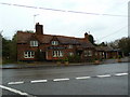
4
Houses in Botley
Looking south-west at the junction of Botley Road and Tyler's Hill Road.
Image: © David Hawgood
Taken: 31 Jan 2006
0.11 miles
5
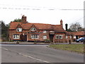
Hen and Chickens inn, Botley
This public house appears on the modern OS map, and on one from the 1940s. Photo from the south.
Image: © David Hawgood
Taken: 31 Jan 2006
0.11 miles
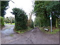
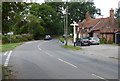
6
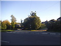
Botley Road at the junction of Tylers Hill Road
Image: © David Howard
Taken: 10 Sep 2015
0.12 miles
9
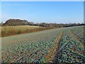
Farmland, Chesham
A crop of oil-seed rape near the head of a dry valley below Botley.
Image: © Andrew Smith
Taken: 4 Feb 2012
0.14 miles
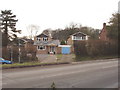
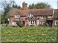
10
Hen & Chickens public house at Botley
Image: © Mat Fascione
Taken: 18 Aug 2015
0.14 miles