IMAGES TAKEN NEAR TO
Hodds Wood Road, CHESHAM, HP5 1SQ
Introduction
This page details the photographs taken nearby to Hodds Wood Road, HP5 1SQ by members of the Geograph project.
The Geograph project started in 2005 with the aim of publishing, organising and preserving representative images for every square kilometre of Great Britain, Ireland and the Isle of Man.

There are currently over 7.5m images from over14,400 individuals and you can help contribute to the project by visiting https://www.geograph.org.uk
Image Map
Images are licensed for reuse under creativecommons.org/licenses/by-sa/2.0
Notes
- Clicking on the map will re-center to the selected point.
- The higher the marker number, the further away the image location is from the centre of the postcode.
Image Listing (48 Images Found)
Images are licensed for reuse under creativecommons.org/licenses/by-sa/2.0
Image
Details
Distance
2
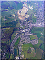
Waterside from the air
Waterside is located between Chesham and Chesham Bois. Viewed from a Heathrow bound flight from Glasgow.
Image: © Thomas Nugent
Taken: 10 Apr 2011
0.07 miles
3
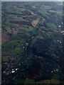
Waterside and Amersham from the Air
Waterside is on the left, Amersham on the right, the River Chess runs through the centre.
Image: © Thomas Nugent
Taken: 24 Nov 2014
0.07 miles
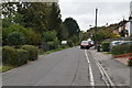
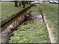
5
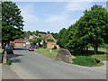
Bois Moor Road, Chesham
Bois Moor Road crosses a small stream on the outskirts of Chesham, Buckinghamshire.
Image: © Malc McDonald
Taken: 4 Jun 2011
0.08 miles
6
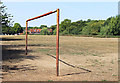
Rusty Goal on Chesham Moor
Chesham Moor is a low lying area of flat grassland between two branches of the River Chess. The hot dry weather of Summer 2018 has got the grass looking almost as brown as this rusty goal post.
Image: © Des Blenkinsopp
Taken: 6 Aug 2018
0.08 miles
7
Chesham: Bois Moor Road bridge parapets
These two comparatively small but quite prominent bridge parapets protect what is an important culvert under the road, as it is appears to be the only surface location where the River Chess can cross under the road apart from the main one at the former Lord's Mill. There is a stone plaque in the right one in this photograph with some text and a date that reads 1860.
Image: © Nigel Cox
Taken: 13 Sep 2018
0.09 miles
8
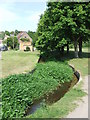
Stream near Chesham
A shallow stream on the outskirts of Chesham, Buckinghamshire
Image: © Malc McDonald
Taken: 4 Jun 2011
0.10 miles
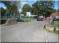
9
Water channel near the start of the Chess Valley Walk, Chesham
Image: © Peter S
Taken: 28 Mar 2013
0.11 miles
10
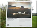
The River Meadow at the Pile of Stones Board- The Chess Valley
This board is one of ten on Chesham Moor with photographs by Matt Writtle. It has the following wording:
THE RIVER MEADOW AT THE PILE OF STONES.
THE CHESS VALLEY
As the River Chess bids farewell to Chesham, it flows through the picturesque Chess Valley
towards the site of a Roman Villa now known as Latimer Park. As well as a hotel, fisheries,
charities and small businesses, the land is farmed for wheat and barley and livestock. Once
the sheep have weaned their lambs, they spend three months, from August to October, grazing
on the river meadow next to the Chess, gorging on the rich variety of grasses and wildflower.
This restores the sheep's health and condition more speedily than traditional pastures, in
preparation for the mating season in November. At the same time the sheep tread the seeds
from the flowering plants into the earth to help the germination process, whose benefits are
reaped the following spring by pollinating insects, birds, mammals and the wider ecology.
Image: © David Hillas
Taken: 12 Oct 2023
0.12 miles